

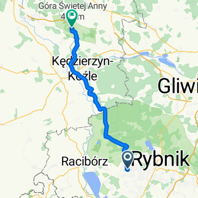
Dokoła Raciborza 1
A cycling route starting in Czernica, Silesian Voivodeship, Poland.
Overview
About this route
- -:--
- Duration
- 52.8 km
- Distance
- 322 m
- Ascent
- 322 m
- Descent
- ---
- Avg. speed
- ---
- Max. altitude

Route quality
Waytypes & surfaces along the route
Waytypes
Road
17.8 km
(34 %)
Quiet road
12.6 km
(24 %)
Surfaces
Paved
33.7 km
(64 %)
Unpaved
8.2 km
(16 %)
Asphalt
27.6 km
(52 %)
Ground
7.3 km
(14 %)
Continue with Bikemap
Use, edit, or download this cycling route
You would like to ride Dokoła Raciborza 1 or customize it for your own trip? Here is what you can do with this Bikemap route:
Free features
- Save this route as favorite or in collections
- Copy & plan your own version of this route
- Sync your route with Garmin or Wahoo
Premium features
Free trial for 3 days, or one-time payment. More about Bikemap Premium.
- Navigate this route on iOS & Android
- Export a GPX / KML file of this route
- Create your custom printout (try it for free)
- Download this route for offline navigation
Discover more Premium features.
Get Bikemap PremiumFrom our community
Other popular routes starting in Czernica
 Czernica - Annaberg
- Distance
- 57.5 km
- Ascent
- 271 m
- Descent
- 191 m
- Location
- Czernica, Silesian Voivodeship, Poland
 Czernica - Kuźnia - Rudy - Rybnik - Czernica
- Distance
- 64 km
- Ascent
- 239 m
- Descent
- 239 m
- Location
- Czernica, Silesian Voivodeship, Poland
 Powstańców, Czernica do Chwałęcice, Rybnik
- Distance
- 12.6 km
- Ascent
- 83 m
- Descent
- 132 m
- Location
- Czernica, Silesian Voivodeship, Poland
 Jezioro Rybnickie
- Distance
- 49.4 km
- Ascent
- 312 m
- Descent
- 300 m
- Location
- Czernica, Silesian Voivodeship, Poland
 Graniczna 10, Czernica do Graniczna 10, Czernica
- Distance
- 20 km
- Ascent
- 223 m
- Descent
- 224 m
- Location
- Czernica, Silesian Voivodeship, Poland
 Piecowska 1, Rydułtowy do Raciborska 417, Rydułtowy
- Distance
- 25 km
- Ascent
- 233 m
- Descent
- 230 m
- Location
- Czernica, Silesian Voivodeship, Poland
 rydultowy
- Distance
- 22.2 km
- Ascent
- 22 m
- Descent
- 60 m
- Location
- Czernica, Silesian Voivodeship, Poland
 Wolności 35, Łuków do Wolności 36, Łuków
- Distance
- 19 km
- Ascent
- 291 m
- Descent
- 302 m
- Location
- Czernica, Silesian Voivodeship, Poland
Open it in the app