

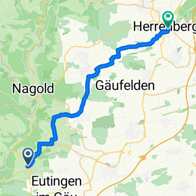
Warmfahrrunde
A cycling route starting in Mötzingen, Baden-Wurttemberg, Germany.
Overview
About this route
Zum Einstieg und warmfahren
- -:--
- Duration
- 14.3 km
- Distance
- 139 m
- Ascent
- 143 m
- Descent
- ---
- Avg. speed
- 574 m
- Max. altitude
Route quality
Waytypes & surfaces along the route
Waytypes
Track
10.9 km
(76 %)
Quiet road
2.2 km
(15 %)
Surfaces
Paved
6.1 km
(43 %)
Unpaved
6.7 km
(47 %)
Gravel
5.9 km
(42 %)
Asphalt
5.5 km
(38 %)
Continue with Bikemap
Use, edit, or download this cycling route
You would like to ride Warmfahrrunde or customize it for your own trip? Here is what you can do with this Bikemap route:
Free features
- Save this route as favorite or in collections
- Copy & plan your own version of this route
- Sync your route with Garmin or Wahoo
Premium features
Free trial for 3 days, or one-time payment. More about Bikemap Premium.
- Navigate this route on iOS & Android
- Export a GPX / KML file of this route
- Create your custom printout (try it for free)
- Download this route for offline navigation
Discover more Premium features.
Get Bikemap PremiumFrom our community
Other popular routes starting in Mötzingen
 (planned) Neckar-Tal - Kloster Kirchberg - Neckar- Eyach-Tal
- Distance
- 109.3 km
- Ascent
- 898 m
- Descent
- 899 m
- Location
- Mötzingen, Baden-Wurttemberg, Germany
 TÜ Bebenhausen Entringen
- Distance
- 55.4 km
- Ascent
- 479 m
- Descent
- 475 m
- Location
- Mötzingen, Baden-Wurttemberg, Germany
 Mötzingen - Baisingen (Variante2)
- Distance
- 4.2 km
- Ascent
- 57 m
- Descent
- 87 m
- Location
- Mötzingen, Baden-Wurttemberg, Germany
 Baisingen-Altnuifra-Haiterbach-Baisingen
- Distance
- 38.2 km
- Ascent
- 856 m
- Descent
- 849 m
- Location
- Mötzingen, Baden-Wurttemberg, Germany
 PC FamilienRadTour 2011
- Distance
- 25 km
- Ascent
- 301 m
- Descent
- 302 m
- Location
- Mötzingen, Baden-Wurttemberg, Germany
 Gänsäckerweg nach Marktplatz
- Distance
- 20.8 km
- Ascent
- 147 m
- Descent
- 276 m
- Location
- Mötzingen, Baden-Wurttemberg, Germany
 Kochhartgraben - Kirchheim Teck
- Distance
- 65.2 km
- Ascent
- 586 m
- Descent
- 879 m
- Location
- Mötzingen, Baden-Wurttemberg, Germany
 Warmfahrrunde
- Distance
- 14.3 km
- Ascent
- 139 m
- Descent
- 143 m
- Location
- Mötzingen, Baden-Wurttemberg, Germany
Open it in the app