
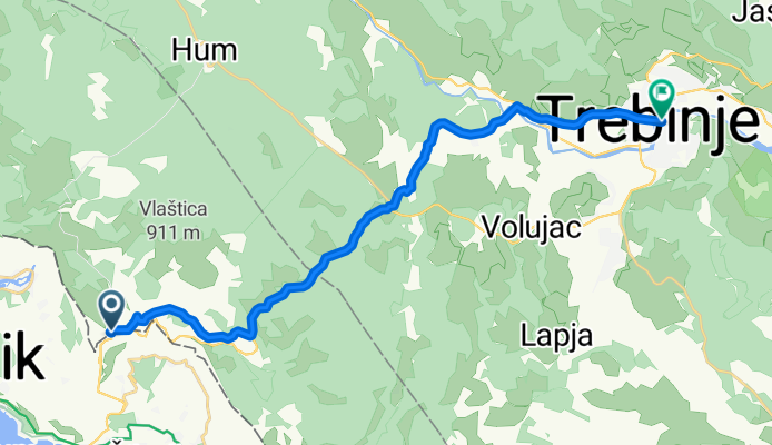
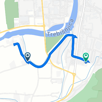
Granica BiH i Hrvatska do Trebinja
A cycling route starting in Trebinje, Republika Srpska, Bosnia and Herzegovina.
Overview
About this route
- -:--
- Duration
- 20.8 km
- Distance
- 214 m
- Ascent
- 267 m
- Descent
- ---
- Avg. speed
- ---
- Max. altitude
Route quality
Waytypes & surfaces along the route
Waytypes
Busy road
6.8 km
(33 %)
Road
6.2 km
(30 %)
Surfaces
Paved
13.7 km
(66 %)
Unpaved
3.9 km
(19 %)
Paved (undefined)
7.9 km
(38 %)
Asphalt
5.8 km
(28 %)
Continue with Bikemap
Use, edit, or download this cycling route
You would like to ride Granica BiH i Hrvatska do Trebinja or customize it for your own trip? Here is what you can do with this Bikemap route:
Free features
- Save this route as favorite or in collections
- Copy & plan your own version of this route
- Sync your route with Garmin or Wahoo
Premium features
Free trial for 3 days, or one-time payment. More about Bikemap Premium.
- Navigate this route on iOS & Android
- Export a GPX / KML file of this route
- Create your custom printout (try it for free)
- Download this route for offline navigation
Discover more Premium features.
Get Bikemap PremiumFrom our community
Other popular routes starting in Trebinje
 Slow ride
- Distance
- 2.3 km
- Ascent
- 0 m
- Descent
- 41 m
- Location
- Trebinje, Republika Srpska, Bosnia and Herzegovina
 Tour 2018 Tag 10
- Distance
- 71.2 km
- Ascent
- 706 m
- Descent
- 977 m
- Location
- Trebinje, Republika Srpska, Bosnia and Herzegovina
 10. Tag Trebinj Slano
- Distance
- 70.9 km
- Ascent
- 667 m
- Descent
- 916 m
- Location
- Trebinje, Republika Srpska, Bosnia and Herzegovina
 gggggggggggggggggggggg
- Distance
- 88.4 km
- Ascent
- 811 m
- Descent
- 1,088 m
- Location
- Trebinje, Republika Srpska, Bosnia and Herzegovina
 01 Trebinje to Herceg Novi
- Distance
- 58.1 km
- Ascent
- 1,285 m
- Descent
- 1,559 m
- Location
- Trebinje, Republika Srpska, Bosnia and Herzegovina
 Trebinje Risan
- Distance
- 64 km
- Ascent
- 1,283 m
- Descent
- 1,559 m
- Location
- Trebinje, Republika Srpska, Bosnia and Herzegovina
 Ciro Ruta v1
- Distance
- 299.5 km
- Ascent
- 4,188 m
- Descent
- 4,499 m
- Location
- Trebinje, Republika Srpska, Bosnia and Herzegovina
 Trebinje - Meljine kružni tok
- Distance
- 41.6 km
- Ascent
- 652 m
- Descent
- 923 m
- Location
- Trebinje, Republika Srpska, Bosnia and Herzegovina
Open it in the app