
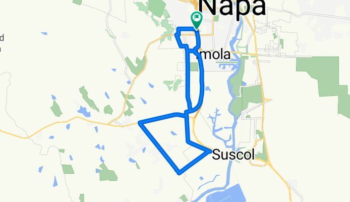
Napa Route
A cycling route starting in Napa, California, United States.
Overview
About this route
- -:--
- Duration
- 17.5 km
- Distance
- 94 m
- Ascent
- 92 m
- Descent
- ---
- Avg. speed
- ---
- Max. altitude

Continue with Bikemap
Use, edit, or download this cycling route
You would like to ride Napa Route or customize it for your own trip? Here is what you can do with this Bikemap route:
Free features
- Save this route as favorite or in collections
- Copy & plan your own version of this route
- Sync your route with Garmin or Wahoo
Premium features
Free trial for 3 days, or one-time payment. More about Bikemap Premium.
- Navigate this route on iOS & Android
- Export a GPX / KML file of this route
- Create your custom printout (try it for free)
- Download this route for offline navigation
Discover more Premium features.
Get Bikemap PremiumFrom our community
Other popular routes starting in Napa
 Stanly/Carneros Loop 24
- Distance
- 38.2 km
- Ascent
- 243 m
- Descent
- 240 m
- Location
- Napa, California, United States
 Napa to Calistoga
- Distance
- 41.3 km
- Ascent
- 198 m
- Descent
- 102 m
- Location
- Napa, California, United States
 Lorraine. me, escape.. last day of school bve. Napa
- Distance
- 8 km
- Ascent
- 60 m
- Descent
- 60 m
- Location
- Napa, California, United States
 Napa to Mount Veeder
- Distance
- 52.9 km
- Ascent
- 488 m
- Descent
- 488 m
- Location
- Napa, California, United States
 Napa to Yountville
- Distance
- 57.1 km
- Ascent
- 145 m
- Descent
- 145 m
- Location
- Napa, California, United States
 Mt. Veeder Dry Creek Rd Loop
- Distance
- 34.9 km
- Ascent
- 567 m
- Descent
- 572 m
- Location
- Napa, California, United States
 Napa-Vineyards-Dry Creek-Mt Veeder
- Distance
- 68.6 km
- Ascent
- 1,124 m
- Descent
- 1,124 m
- Location
- Napa, California, United States
 Napa Route
- Distance
- 17.5 km
- Ascent
- 94 m
- Descent
- 92 m
- Location
- Napa, California, United States
Open it in the app