

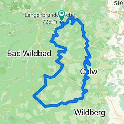
rund um Schömberg
A cycling route starting in Engelsbrand, Baden-Wurttemberg, Germany.
Overview
About this route
- -:--
- Duration
- 16.6 km
- Distance
- 280 m
- Ascent
- 280 m
- Descent
- ---
- Avg. speed
- ---
- Max. altitude
Route quality
Waytypes & surfaces along the route
Waytypes
Track
8.1 km
(49 %)
Quiet road
5 km
(30 %)
Surfaces
Paved
8.4 km
(51 %)
Unpaved
7.5 km
(45 %)
Asphalt
6.5 km
(39 %)
Gravel
4.8 km
(29 %)
Continue with Bikemap
Use, edit, or download this cycling route
You would like to ride rund um Schömberg or customize it for your own trip? Here is what you can do with this Bikemap route:
Free features
- Save this route as favorite or in collections
- Copy & plan your own version of this route
- Sync your route with Garmin or Wahoo
Premium features
Free trial for 3 days, or one-time payment. More about Bikemap Premium.
- Navigate this route on iOS & Android
- Export a GPX / KML file of this route
- Create your custom printout (try it for free)
- Download this route for offline navigation
Discover more Premium features.
Get Bikemap PremiumFrom our community
Other popular routes starting in Engelsbrand
 Neubulach Hofstett
- Distance
- 84.2 km
- Ascent
- 828 m
- Descent
- 828 m
- Location
- Engelsbrand, Baden-Wurttemberg, Germany
 BüchenbonnerHöhe
- Distance
- 7.8 km
- Ascent
- 183 m
- Descent
- 183 m
- Location
- Engelsbrand, Baden-Wurttemberg, Germany
 Rund um Salmbach
- Distance
- 40.8 km
- Ascent
- 586 m
- Descent
- 586 m
- Location
- Engelsbrand, Baden-Wurttemberg, Germany
 Lange Ausfahrt von Engelsbrand nach Schönaich
- Distance
- 42.6 km
- Ascent
- 426 m
- Descent
- 466 m
- Location
- Engelsbrand, Baden-Wurttemberg, Germany
 Über Berg und Tal
- Distance
- 60.6 km
- Ascent
- 842 m
- Descent
- 842 m
- Location
- Engelsbrand, Baden-Wurttemberg, Germany
 Herdweg, Engelsbrand nach Herdweg 6, Engelsbrand
- Distance
- 31.9 km
- Ascent
- 580 m
- Descent
- 584 m
- Location
- Engelsbrand, Baden-Wurttemberg, Germany
 2011-08-01 Montagsrunde
- Distance
- 52.1 km
- Ascent
- 845 m
- Descent
- 845 m
- Location
- Engelsbrand, Baden-Wurttemberg, Germany
 GK_Eulenloch
- Distance
- 17.5 km
- Ascent
- 270 m
- Descent
- 270 m
- Location
- Engelsbrand, Baden-Wurttemberg, Germany
Open it in the app