B2B00395 55127>55101 viaCenterville/Edgerton/Gateway/L'Orient/Jackson
A cycling route starting in Vadnais Heights, Minnesota, United States of America.
Overview
About this route
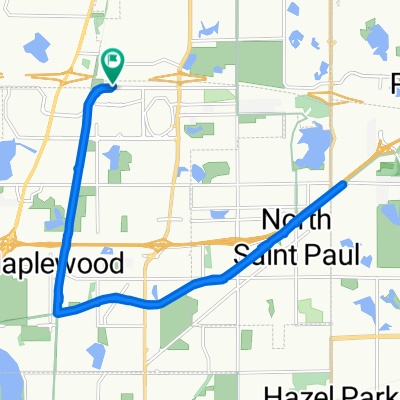
Go south on Centerville Rd until you reach Edgerton Av. Turn left and follow Edgerton over 694, past Lake Gervais, over Hwy. 36, past Forest Lawn Cemetery. Just past the cemetery turn on to the Gateway Trail to the right. Follow the Gateway across 35E and to the end/start of the Trail at Cayuga St. Go straight ahead on L'Orient around Acker St. E. Turn left at Jackson St. and continue past University Av. and over I94 into downtown St. Paul. Turn right at E. 6th St. one block to Robert St. Turn right to your destination.
- -:--
- Duration
- 16.8 km
- Distance
- 41 m
- Ascent
- 85 m
- Descent
- ---
- Avg. speed
- 290 m
- Avg. speed
Route quality
Waytypes & surfaces along the route
Waytypes
Road
9.6 km
(57 %)
Cycleway
5.4 km
(32 %)
Surfaces
Paved
14.7 km
(88 %)
Asphalt
12.2 km
(73 %)
Paved (undefined)
2.4 km
(14 %)
Continue with Bikemap
Use, edit, or download this cycling route
You would like to ride B2B00395 55127>55101 viaCenterville/Edgerton/Gateway/L'Orient/Jackson or customize it for your own trip? Here is what you can do with this Bikemap route:
Free features
- Save this route as favorite or in collections
- Copy & plan your own version of this route
- Sync your route with Garmin or Wahoo
Premium features
Free trial for 3 days, or one-time payment. More about Bikemap Premium.
- Navigate this route on iOS & Android
- Export a GPX / KML file of this route
- Create your custom printout (try it for free)
- Download this route for offline navigation
Discover more Premium features.
Get Bikemap PremiumFrom our community
Other popular routes starting in Vadnais Heights
- The Great Fall Bike Ride
- Distance
- 230.4 km
- Ascent
- 241 m
- Descent
- 229 m
- Location
- Vadnais Heights, Minnesota, United States of America
- Down the Bruce and back ALT
- Distance
- 33.4 km
- Ascent
- 130 m
- Descent
- 130 m
- Location
- Vadnais Heights, Minnesota, United States of America
- B2B00457 55127>55110 Centervl/GooseLk/Hoffman/WhiteBear/S.Shore/Century
- Distance
- 11.9 km
- Ascent
- 61 m
- Descent
- 29 m
- Location
- Vadnais Heights, Minnesota, United States of America
- B2B00159 55127 > 55449 via rice, lexington, and cty rd j
- Distance
- 15.3 km
- Ascent
- 9 m
- Descent
- 16 m
- Location
- Vadnais Heights, Minnesota, United States of America
- B2B00457 55127>55110 Centervl/GooseLk/Hoffman/WhiteBear/S.Shore/Century
- Distance
- 11.8 km
- Ascent
- 75 m
- Descent
- 39 m
- Location
- Vadnais Heights, Minnesota, United States of America
- 45.036° N -93.052° W to 45.065° N -93.024° W
- Distance
- 33 km
- Ascent
- 239 m
- Descent
- 243 m
- Location
- Vadnais Heights, Minnesota, United States of America
- Scandia
- Distance
- 79.7 km
- Ascent
- 153 m
- Descent
- 153 m
- Location
- Vadnais Heights, Minnesota, United States of America
- Rick's house around White Bear Lake
- Distance
- 26.9 km
- Ascent
- 103 m
- Descent
- 97 m
- Location
- Vadnais Heights, Minnesota, United States of America
Open it in the app