first try
A cycling route starting in Sainte-Consorce, Auvergne-Rhône-Alpes, France.
Overview
About this route
- -:--
- Duration
- 27 km
- Distance
- 675 m
- Ascent
- 666 m
- Descent
- ---
- Avg. speed
- ---
- Max. altitude
Route quality
Waytypes & surfaces along the route
Waytypes
Road
17.6 km
(65 %)
Track
2.7 km
(10 %)
Surfaces
Paved
15.4 km
(57 %)
Unpaved
2.7 km
(10 %)
Asphalt
15.4 km
(57 %)
Ground
2.2 km
(8 %)
Continue with Bikemap
Use, edit, or download this cycling route
You would like to ride first try or customize it for your own trip? Here is what you can do with this Bikemap route:
Free features
- Save this route as favorite or in collections
- Copy & plan your own version of this route
- Sync your route with Garmin or Wahoo
Premium features
Free trial for 3 days, or one-time payment. More about Bikemap Premium.
- Navigate this route on iOS & Android
- Export a GPX / KML file of this route
- Create your custom printout (try it for free)
- Download this route for offline navigation
Discover more Premium features.
Get Bikemap PremiumFrom our community
Other popular routes starting in Sainte-Consorce
balade vélo famille- Distance
- 12.5 km
- Ascent
- 289 m
- Descent
- 283 m
- Location
- Sainte-Consorce, Auvergne-Rhône-Alpes, France
Ste Consorce- Distance
- 13.9 km
- Ascent
- 571 m
- Descent
- 527 m
- Location
- Sainte-Consorce, Auvergne-Rhône-Alpes, France
De 42 Chemin des Églantines, Marcy-l'Étoile à 16–180 Chemin des Alouettes, Vaugneray- Distance
- 9.6 km
- Ascent
- 209 m
- Descent
- 168 m
- Location
- Sainte-Consorce, Auvergne-Rhône-Alpes, France
Le pilat V2- Distance
- 156 km
- Ascent
- 2,191 m
- Descent
- 2,197 m
- Location
- Sainte-Consorce, Auvergne-Rhône-Alpes, France
Monts du Lyonnis- Distance
- 49 km
- Ascent
- 1,135 m
- Descent
- 1,078 m
- Location
- Sainte-Consorce, Auvergne-Rhône-Alpes, France
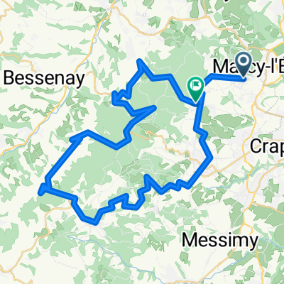
marcy 1h vélo - col de la croix du ban- Distance
- 21.4 km
- Ascent
- 402 m
- Descent
- 402 m
- Location
- Sainte-Consorce, Auvergne-Rhône-Alpes, France
De Chemin de l'Hôpital 71F, Sainte-Consorce à Impasse Rivoire 5, Saint-Genis-Laval- Distance
- 16.9 km
- Ascent
- 183 m
- Descent
- 314 m
- Location
- Sainte-Consorce, Auvergne-Rhône-Alpes, France
VTT Monts Lyonnais - Chapel- Distance
- 21.1 km
- Ascent
- 389 m
- Descent
- 390 m
- Location
- Sainte-Consorce, Auvergne-Rhône-Alpes, France
Open it in the app


