

2015 Alpencross GTA
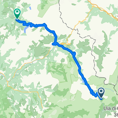
Lanslevillard - Susa
A cycling route starting in Val d'Isère, Auvergne-Rhône-Alpes, France.
Overview
About this route
- -:--
- Duration
- 66.3 km
- Distance
- 1,407 m
- Ascent
- 2,382 m
- Descent
- ---
- Avg. speed
- ---
- Max. altitude

Part of
2015 Alpencross GTA
9 stages
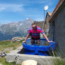
Route photos


Continue with Bikemap
Use, edit, or download this cycling route
You would like to ride Lanslevillard - Susa or customize it for your own trip? Here is what you can do with this Bikemap route:
Free features
- Save this route as favorite or in collections
- Copy & plan your own version of this route
- Sync your route with Garmin or Wahoo
Premium features
Free trial for 3 days, or one-time payment. More about Bikemap Premium.
- Navigate this route on iOS & Android
- Export a GPX / KML file of this route
- Create your custom printout (try it for free)
- Download this route for offline navigation
Discover more Premium features.
Get Bikemap PremiumFrom our community
Other popular routes starting in Val d'Isère
 Route des Grandes Alpes stage 4
- Distance
- 115.2 km
- Ascent
- 2,038 m
- Descent
- 2,286 m
- Location
- Val d'Isère, Auvergne-Rhône-Alpes, France
 RdGA - Stage 4
- Distance
- 115.2 km
- Ascent
- 2,067 m
- Descent
- 2,315 m
- Location
- Val d'Isère, Auvergne-Rhône-Alpes, France
 Tag 7. Val d Isere - Briancon Alternativ
- Distance
- 159.9 km
- Ascent
- 3,013 m
- Descent
- 3,633 m
- Location
- Val d'Isère, Auvergne-Rhône-Alpes, France
 Val-d'Isère - Beaufort
- Distance
- 77.5 km
- Ascent
- 929 m
- Descent
- 2,659 m
- Location
- Val d'Isère, Auvergne-Rhône-Alpes, France
 Cols de Mont Cenis y Petit Mont Cenis
- Distance
- 47 km
- Ascent
- 1,108 m
- Descent
- 1,108 m
- Location
- Val d'Isère, Auvergne-Rhône-Alpes, France
 RdGA Tag 4
- Distance
- 105.1 km
- Ascent
- 1,854 m
- Descent
- 2,275 m
- Location
- Val d'Isère, Auvergne-Rhône-Alpes, France
 021 - 2014
- Distance
- 68.9 km
- Ascent
- 1,825 m
- Descent
- 2,036 m
- Location
- Val d'Isère, Auvergne-Rhône-Alpes, France
 RdGA - Stage 4 (var Aussois)
- Distance
- 115.9 km
- Ascent
- 2,222 m
- Descent
- 2,470 m
- Location
- Val d'Isère, Auvergne-Rhône-Alpes, France
Open it in the app