HN-Stettenfels-Donnbronn-HN
A cycling route starting in Heilbronn, Baden-Wurttemberg, Germany.
Overview
About this route
Quick loop to Stettenfels Castle, via Donnbronn and Köpfertal back to HN. 2 single trails, otherwise asphalt and gravel forest paths.
- -:--
- Duration
- 23.2 km
- Distance
- 282 m
- Ascent
- 282 m
- Descent
- ---
- Avg. speed
- ---
- Max. altitude
Route quality
Waytypes & surfaces along the route
Waytypes
Track
13.2 km
(57 %)
Quiet road
5.1 km
(22 %)
Surfaces
Paved
10.7 km
(46 %)
Unpaved
12.3 km
(53 %)
Asphalt
10.4 km
(45 %)
Gravel
7.4 km
(32 %)
Continue with Bikemap
Use, edit, or download this cycling route
You would like to ride HN-Stettenfels-Donnbronn-HN or customize it for your own trip? Here is what you can do with this Bikemap route:
Free features
- Save this route as favorite or in collections
- Copy & plan your own version of this route
- Sync your route with Garmin or Wahoo
Premium features
Free trial for 3 days, or one-time payment. More about Bikemap Premium.
- Navigate this route on iOS & Android
- Export a GPX / KML file of this route
- Create your custom printout (try it for free)
- Download this route for offline navigation
Discover more Premium features.
Get Bikemap PremiumFrom our community
Other popular routes starting in Heilbronn
Neckarbisch 2 100km Sinsheim- Distance
- 96.1 km
- Ascent
- 1,007 m
- Descent
- 1,025 m
- Location
- Heilbronn, Baden-Wurttemberg, Germany
HN-Stettenfels-Donnbronn-HN- Distance
- 23.2 km
- Ascent
- 282 m
- Descent
- 282 m
- Location
- Heilbronn, Baden-Wurttemberg, Germany
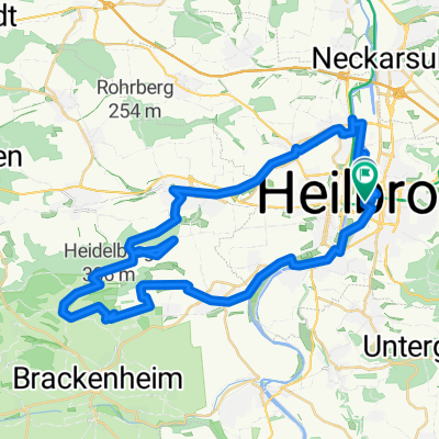
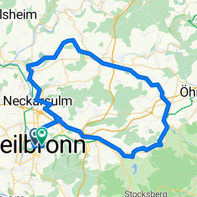
Tour de Hohenlohe - Feierabendtraining- Distance
- 38.9 km
- Ascent
- 381 m
- Descent
- 343 m
- Location
- Heilbronn, Baden-Wurttemberg, Germany
Kocher-Jagst-Tour Teil 1- Distance
- 99.3 km
- Ascent
- 826 m
- Descent
- 724 m
- Location
- Heilbronn, Baden-Wurttemberg, Germany
Lange RSG Radrunde von HN nach Sinsheim und Löwenstein und zurück- Distance
- 101.9 km
- Ascent
- 553 m
- Descent
- 515 m
- Location
- Heilbronn, Baden-Wurttemberg, Germany
Neipperger Runde- Distance
- 36.4 km
- Ascent
- 355 m
- Descent
- 354 m
- Location
- Heilbronn, Baden-Wurttemberg, Germany
Heilbronn - Löwenstein (fast) - Schweinsbergturm - Heilbronn- Distance
- 38.4 km
- Ascent
- 690 m
- Descent
- 562 m
- Location
- Heilbronn, Baden-Wurttemberg, Germany
HN Stadtwaldrunde- Distance
- 26.8 km
- Ascent
- 485 m
- Descent
- 484 m
- Location
- Heilbronn, Baden-Wurttemberg, Germany
Open it in the app

