

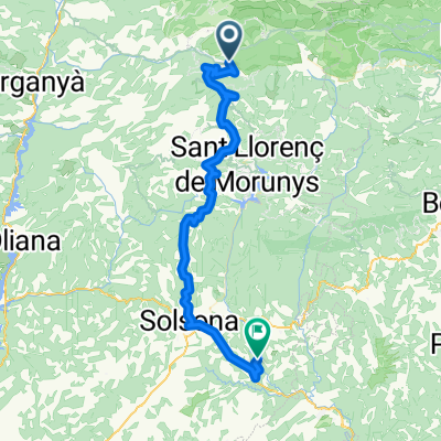
COLL DE JOU (por Sant Llorenç de Morunys)
A cycling route starting in Gósol, Catalonia, Spain.
Overview
About this route
- -:--
- Duration
- 11.5 km
- Distance
- 692 m
- Ascent
- 56 m
- Descent
- ---
- Avg. speed
- ---
- Max. altitude

Route quality
Waytypes & surfaces along the route
Waytypes
Road
9.3 km
(80 %)
Busy road
1.7 km
(14 %)
Surfaces
Paved
9.2 km
(79 %)
Asphalt
9.2 km
(79 %)
Undefined
2.4 km
(21 %)
Continue with Bikemap
Use, edit, or download this cycling route
You would like to ride COLL DE JOU (por Sant Llorenç de Morunys) or customize it for your own trip? Here is what you can do with this Bikemap route:
Free features
- Save this route as favorite or in collections
- Copy & plan your own version of this route
- Sync your route with Garmin or Wahoo
Premium features
Free trial for 3 days, or one-time payment. More about Bikemap Premium.
- Navigate this route on iOS & Android
- Export a GPX / KML file of this route
- Create your custom printout (try it for free)
- Download this route for offline navigation
Discover more Premium features.
Get Bikemap PremiumFrom our community
Other popular routes starting in Gósol
 Sant Llorenç de Morunys-Tuixent-La Seu d'Urgell-S Llorenç
- Distance
- 129.1 km
- Ascent
- 2,608 m
- Descent
- 2,610 m
- Location
- Gósol, Catalonia, Spain
 Tuixent - Solsona - Sant Ponc
- Distance
- 59.5 km
- Ascent
- 1,409 m
- Descent
- 1,926 m
- Location
- Gósol, Catalonia, Spain
 2012_Tag 04_Gósol - Sort
- Distance
- 105.5 km
- Ascent
- 1,837 m
- Descent
- 2,543 m
- Location
- Gósol, Catalonia, Spain
 S.Loorenç-Berga-Coll de pradell-Gosol
- Distance
- 114.1 km
- Ascent
- 2,564 m
- Descent
- 2,562 m
- Location
- Gósol, Catalonia, Spain
 7 Josa I Tuixent - Molló
- Distance
- 108.3 km
- Ascent
- 1,418 m
- Descent
- 1,397 m
- Location
- Gósol, Catalonia, Spain
 St. llorenç-Berga
- Distance
- 115 km
- Ascent
- 2,121 m
- Descent
- 2,097 m
- Location
- Gósol, Catalonia, Spain
 EL MONTNOU
- Distance
- 40.7 km
- Ascent
- 1,211 m
- Descent
- 1,211 m
- Location
- Gósol, Catalonia, Spain
 LA CORRIU PUIG AGUILAR
- Distance
- 38 km
- Ascent
- 933 m
- Descent
- 933 m
- Location
- Gósol, Catalonia, Spain
Open it in the app