

春アフリカ ブルームフォンテン
A cycling route starting in Maseru, Maseru District, Lesotho.
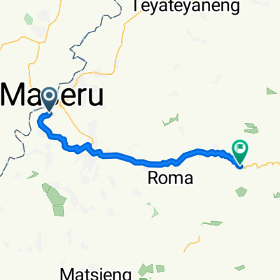
Overview
About this route
- -:--
- Duration
- 179.6 km
- Distance
- 675 m
- Ascent
- 789 m
- Descent
- ---
- Avg. speed
- ---
- Max. altitude

Continue with Bikemap
Use, edit, or download this cycling route
You would like to ride 春アフリカ ブルームフォンテン or customize it for your own trip? Here is what you can do with this Bikemap route:
Free features
- Save this route as favorite or in collections
- Copy & plan your own version of this route
- Split it into stages to create a multi-day tour
- Sync your route with Garmin or Wahoo
Premium features
Free trial for 3 days, or one-time payment. More about Bikemap Premium.
- Navigate this route on iOS & Android
- Export a GPX / KML file of this route
- Create your custom printout (try it for free)
- Download this route for offline navigation
Discover more Premium features.
Get Bikemap PremiumFrom our community
Other popular routes starting in Maseru
 Supersonic route
- Distance
- 7.4 km
- Ascent
- 138 m
- Descent
- 119 m
- Location
- Maseru, Maseru District, Lesotho
 春アフリカ ブルームフォンテン
- Distance
- 179.6 km
- Ascent
- 675 m
- Descent
- 789 m
- Location
- Maseru, Maseru District, Lesotho
 Maseru to -29.433° N 27.570° W
- Distance
- 21.1 km
- Ascent
- 244 m
- Descent
- 179 m
- Location
- Maseru, Maseru District, Lesotho
 25B-MASERU-BLOEMFONTEIN
- Distance
- 148.1 km
- Ascent
- 518 m
- Descent
- 681 m
- Location
- Maseru, Maseru District, Lesotho
 Maseru-Masite Nek por el aeropuerto
- Distance
- 39.5 km
- Ascent
- 461 m
- Descent
- 357 m
- Location
- Maseru, Maseru District, Lesotho
 Kaapstad03
- Distance
- 1,354.5 km
- Ascent
- 6,785 m
- Descent
- 6,945 m
- Location
- Maseru, Maseru District, Lesotho
 Moderate route in Maseru
- Distance
- 16.7 km
- Ascent
- 125 m
- Descent
- 108 m
- Location
- Maseru, Maseru District, Lesotho
 Ruta Maseru-Fosi
- Distance
- 52.8 km
- Ascent
- 1,199 m
- Descent
- 486 m
- Location
- Maseru, Maseru District, Lesotho
Open it in the app