

Hiesberg, Ruine Zelking - Variante I
A cycling route starting in Mank, Lower Austria, Austria.
Overview
About this route
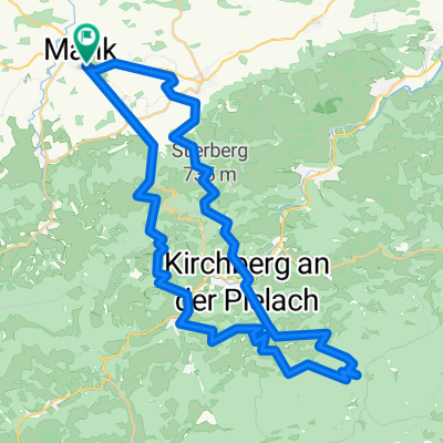
Departure from the parking lot Maidengasse via Kälberhart, Neustift, Eisguggen onto Hiesberg. Over the road (Weichselbach-Melk) to Pulverturm and further to ROGLSTEIN.
After a casual descent, one reaches RUINE ZELKING.
From there, it goes up 150 m to EISERNEN BILD.
Now, down the forest road, 200 m down to the town of Au. Cross the road straight over and after the bridge turn left along the Melk river. Passing MANKMÜNDUNG to Ruprechtshofen. Through the town to St. Leonhard and up to Kaltenbrunner Höhe. Then down to Ritzenberg, St. Haus, and Busendorf.
Back over the new residential area Mank West to the starting point.
Route length 40 km with pleasant climbs of 900 m. Some endurance and technique won't hurt.
- -:--
- Duration
- 39.4 km
- Distance
- 686 m
- Ascent
- 685 m
- Descent
- ---
- Avg. speed
- ---
- Max. altitude

Route photos


Route quality
Waytypes & surfaces along the route
Waytypes
Track
25.2 km
(64 %)
Path
3.9 km
(10 %)
Surfaces
Paved
3.2 km
(8 %)
Unpaved
22.5 km
(57 %)
Gravel
8.3 km
(21 %)
Ground
7.9 km
(20 %)
Route highlights
Points of interest along the route
Point of interest after 18.2 km
Pulverturm (= fiktive Bezeichnung; Turm steht hier keiner mehr)

Point of interest after 19.8 km
Roglstein

Point of interest after 21.3 km
Ruine Zelking

Point of interest after 22.9 km
Eisernes Bild

Point of interest after 28.2 km
Mankmündung
Continue with Bikemap
Use, edit, or download this cycling route
You would like to ride Hiesberg, Ruine Zelking - Variante I or customize it for your own trip? Here is what you can do with this Bikemap route:
Free features
- Save this route as favorite or in collections
- Copy & plan your own version of this route
- Sync your route with Garmin or Wahoo
Premium features
Free trial for 3 days, or one-time payment. More about Bikemap Premium.
- Navigate this route on iOS & Android
- Export a GPX / KML file of this route
- Create your custom printout (try it for free)
- Download this route for offline navigation
Discover more Premium features.
Get Bikemap PremiumFrom our community
Other popular routes starting in Mank
 Zeitmeßstrecke f. Luki
- Distance
- 23 km
- Ascent
- 224 m
- Descent
- 229 m
- Location
- Mank, Lower Austria, Austria
 AustriaTour_czI - Mank-Villach
- Distance
- 569 km
- Ascent
- 3,252 m
- Descent
- 3,052 m
- Location
- Mank, Lower Austria, Austria
 Hiesberg, Ruine Zelking - Variante I
- Distance
- 39.4 km
- Ascent
- 686 m
- Descent
- 685 m
- Location
- Mank, Lower Austria, Austria
 Mank - Texingtal - Mank
- Distance
- 25.2 km
- Ascent
- 380 m
- Descent
- 380 m
- Location
- Mank, Lower Austria, Austria
 Schöngrabenrunde
- Distance
- 54.8 km
- Ascent
- 1,825 m
- Descent
- 1,826 m
- Location
- Mank, Lower Austria, Austria
 Mank-Hofstetten-Mank
- Distance
- 49.2 km
- Ascent
- 825 m
- Descent
- 825 m
- Location
- Mank, Lower Austria, Austria
 Hochsteinberg-GeheimtippRunde
- Distance
- 26.2 km
- Ascent
- 613 m
- Descent
- 610 m
- Location
- Mank, Lower Austria, Austria
 Flache Runde
- Distance
- 73.9 km
- Ascent
- 1,072 m
- Descent
- 1,080 m
- Location
- Mank, Lower Austria, Austria
Open it in the app