

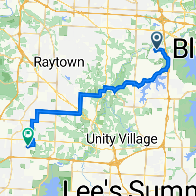
little blue trace 1
A cycling route starting in Blue Springs, Missouri, United States.
Overview
About this route
- 48 min
- Duration
- 8.6 km
- Distance
- 95 m
- Ascent
- 96 m
- Descent
- 10.7 km/h
- Avg. speed
- ---
- Max. altitude

Route photos


Continue with Bikemap
Use, edit, or download this cycling route
You would like to ride little blue trace 1 or customize it for your own trip? Here is what you can do with this Bikemap route:
Free features
- Save this route as favorite or in collections
- Copy & plan your own version of this route
- Sync your route with Garmin or Wahoo
Premium features
Free trial for 3 days, or one-time payment. More about Bikemap Premium.
- Navigate this route on iOS & Android
- Export a GPX / KML file of this route
- Create your custom printout (try it for free)
- Download this route for offline navigation
Discover more Premium features.
Get Bikemap PremiumFrom our community
Other popular routes starting in Blue Springs
 park
park- Distance
- 0.9 km
- Ascent
- 8 m
- Descent
- 8 m
- Location
- Blue Springs, Missouri, United States
 2/8/17 Evening Ride
- Distance
- 11.8 km
- Ascent
- 37 m
- Descent
- 38 m
- Location
- Blue Springs, Missouri, United States
 Night ride 2025
- Distance
- 24.7 km
- Ascent
- 164 m
- Descent
- 164 m
- Location
- Blue Springs, Missouri, United States
 2/17 Ride
- Distance
- 10.6 km
- Ascent
- 127 m
- Descent
- 117 m
- Location
- Blue Springs, Missouri, United States
 Northwest Eclipse Court 2209, Blue Springs to Northwest Eclipse Court 2201, Blue Springs
- Distance
- 2.5 km
- Ascent
- 44 m
- Descent
- 3 m
- Location
- Blue Springs, Missouri, United States
 little blue trace 1
- Distance
- 8.6 km
- Ascent
- 95 m
- Descent
- 96 m
- Location
- Blue Springs, Missouri, United States
 5909 NE Coral Cir, Lee's Summit to 9718 Donnelly Ave, Kansas City
- Distance
- 20.9 km
- Ascent
- 226 m
- Descent
- 172 m
- Location
- Blue Springs, Missouri, United States
 MO’s crib
- Distance
- 6.8 km
- Ascent
- 80 m
- Descent
- 26 m
- Location
- Blue Springs, Missouri, United States
Open it in the app