市政公園-向上特三-中沙-大肚-藍色公路-市政公園
A cycling route starting in Taichung, Taiwan, Taiwan.
Overview
About this route
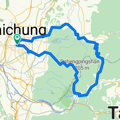
Starting point Municipal Park (Wenxin Road) -> Xiangshang Road -> Zhongsha Road -> Longxin Road -> Shatian Road -> Huanan Road (Blue Highway) -> Youyuan Road -> Xinxing Road -> Taiwan Avenue -> Wenxin Road -> Municipal Park
- -:--
- Duration
- 36.3 km
- Distance
- 463 m
- Ascent
- 464 m
- Descent
- ---
- Avg. speed
- ---
- Max. altitude
Route highlights
Points of interest along the route

Point of interest after 0.1 km
台中市政公園
Continue with Bikemap
Use, edit, or download this cycling route
You would like to ride 市政公園-向上特三-中沙-大肚-藍色公路-市政公園 or customize it for your own trip? Here is what you can do with this Bikemap route:
Free features
- Save this route as favorite or in collections
- Copy & plan your own version of this route
- Sync your route with Garmin or Wahoo
Premium features
Free trial for 3 days, or one-time payment. More about Bikemap Premium.
- Navigate this route on iOS & Android
- Export a GPX / KML file of this route
- Create your custom printout (try it for free)
- Download this route for offline navigation
Discover more Premium features.
Get Bikemap PremiumFrom our community
Other popular routes starting in Taichung
 東山路-大雪山
- Distance
- 47.1 km
- Ascent
- 1,841 m
- Descent
- 160 m
- Location
- Taichung, Taiwan, Taiwan
 台中縣136
- Distance
- 32.3 km
- Ascent
- 1,172 m
- Descent
- 997 m
- Location
- Taichung, Taiwan, Taiwan
 德利路_十四窯坪_大石壁_牛角坑_德利路
- Distance
- 10.3 km
- Ascent
- 480 m
- Descent
- 483 m
- Location
- Taichung, Taiwan, Taiwan
 龍寶橋_後壁涼亭
- Distance
- 3.7 km
- Ascent
- 334 m
- Descent
- 176 m
- Location
- Taichung, Taiwan, Taiwan
 Blue Road
- Distance
- 35.9 km
- Ascent
- 310 m
- Descent
- 309 m
- Location
- Taichung, Taiwan, Taiwan
 6/27_Day 3_台中-嘉義-住宿
- Distance
- 113.8 km
- Ascent
- 89 m
- Descent
- 148 m
- Location
- Taichung, Taiwan, Taiwan
 市政公園-向上特三-中沙-大肚-藍色公路-市政公園
- Distance
- 36.3 km
- Ascent
- 463 m
- Descent
- 464 m
- Location
- Taichung, Taiwan, Taiwan
 天冷+136
- Distance
- 99.7 km
- Ascent
- 1,364 m
- Descent
- 1,366 m
- Location
- Taichung, Taiwan, Taiwan
Open it in the app


