

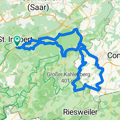
20220705_visavis-puttelange_90,5km-710hm
A cycling route starting in Sankt Ingbert, Saarland, Germany.
Overview
About this route
20220705_visavis-puttelange
güdingen - großblittersdorf - hundling - metzing - hoste - puttelange - grundviller - hambach - saareguemines - heim
- -:--
- Duration
- 90.5 km
- Distance
- 940 m
- Ascent
- 941 m
- Descent
- ---
- Avg. speed
- 312 m
- Max. altitude

Route quality
Waytypes & surfaces along the route
Waytypes
Access road
24.4 km
(27 %)
Quiet road
22.6 km
(25 %)
Surfaces
Paved
70.6 km
(78 %)
Asphalt
62.5 km
(69 %)
Paved (undefined)
8.1 km
(9 %)
Undefined
19.9 km
(22 %)
Route highlights
Points of interest along the route
Point of interest after 46.2 km
Pause
Continue with Bikemap
Use, edit, or download this cycling route
You would like to ride 20220705_visavis-puttelange_90,5km-710hm or customize it for your own trip? Here is what you can do with this Bikemap route:
Free features
- Save this route as favorite or in collections
- Copy & plan your own version of this route
- Split it into stages to create a multi-day tour
- Sync your route with Garmin or Wahoo
Premium features
Free trial for 3 days, or one-time payment. More about Bikemap Premium.
- Navigate this route on iOS & Android
- Export a GPX / KML file of this route
- Create your custom printout (try it for free)
- Download this route for offline navigation
Discover more Premium features.
Get Bikemap PremiumFrom our community
Other popular routes starting in Sankt Ingbert
 Blieskastel
- Distance
- 40.1 km
- Ascent
- 313 m
- Descent
- 313 m
- Location
- Sankt Ingbert, Saarland, Germany
 IGB Kurz
- Distance
- 23 km
- Ascent
- 498 m
- Descent
- 497 m
- Location
- Sankt Ingbert, Saarland, Germany
 kleine Frankreichrunde von St. Ingbert aus.
- Distance
- 83.3 km
- Ascent
- 808 m
- Descent
- 744 m
- Location
- Sankt Ingbert, Saarland, Germany
 Grüne PUR
- Distance
- 41.4 km
- Ascent
- 572 m
- Descent
- 572 m
- Location
- Sankt Ingbert, Saarland, Germany
 Wassergarten der Grube Reden
- Distance
- 32.9 km
- Ascent
- 380 m
- Descent
- 380 m
- Location
- Sankt Ingbert, Saarland, Germany
 GTF 77 km 757 Hm
- Distance
- 77.5 km
- Ascent
- 673 m
- Descent
- 671 m
- Location
- Sankt Ingbert, Saarland, Germany
 GTF 146 km 1.516 Hm
- Distance
- 146.2 km
- Ascent
- 1,286 m
- Descent
- 1,284 m
- Location
- Sankt Ingbert, Saarland, Germany
 20220705_visavis-puttelange_90,5km-710hm
- Distance
- 90.5 km
- Ascent
- 940 m
- Descent
- 941 m
- Location
- Sankt Ingbert, Saarland, Germany
Open it in the app