

Neinmeyer Campground
A cycling route starting in Boise, Idaho, United States.
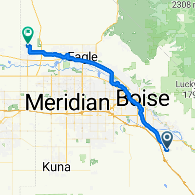
Overview
About this route
- -:--
- Duration
- 285.1 km
- Distance
- 2,510 m
- Ascent
- 2,821 m
- Descent
- ---
- Avg. speed
- ---
- Max. altitude

Route quality
Waytypes & surfaces along the route
Waytypes
Quiet road
213.9 km
(75 %)
Road
39.9 km
(14 %)
Surfaces
Paved
51.3 km
(18 %)
Unpaved
179.6 km
(63 %)
Unpaved (undefined)
154 km
(54 %)
Asphalt
51.3 km
(18 %)
Route highlights
Points of interest along the route
Point of interest after 70.9 km
Neinmeyer campground
Continue with Bikemap
Use, edit, or download this cycling route
You would like to ride Neinmeyer Campground or customize it for your own trip? Here is what you can do with this Bikemap route:
Free features
- Save this route as favorite or in collections
- Copy & plan your own version of this route
- Split it into stages to create a multi-day tour
- Sync your route with Garmin or Wahoo
Premium features
Free trial for 3 days, or one-time payment. More about Bikemap Premium.
- Navigate this route on iOS & Android
- Export a GPX / KML file of this route
- Create your custom printout (try it for free)
- Download this route for offline navigation
Discover more Premium features.
Get Bikemap PremiumFrom our community
Other popular routes starting in Boise
 E Tiger Lily Dr, Boise to E 12th North St, Mountain Home
- Distance
- 78.2 km
- Ascent
- 1,029 m
- Descent
- 957 m
- Location
- Boise, Idaho, United States
 Boise Greenbelt Trail, Boise to E Front Runner Ln, Boise
- Distance
- 9.4 km
- Ascent
- 31 m
- Descent
- 10 m
- Location
- Boise, Idaho, United States
 Boise River Take Out to Home
- Distance
- 9.4 km
- Ascent
- 39 m
- Descent
- 20 m
- Location
- Boise, Idaho, United States
 Neinmeyer Campground
- Distance
- 285.1 km
- Ascent
- 2,510 m
- Descent
- 2,821 m
- Location
- Boise, Idaho, United States
 Rocky Canyon -Boise Ridge-Cretline
- Distance
- 46.4 km
- Ascent
- 1,274 m
- Descent
- 1,267 m
- Location
- Boise, Idaho, United States
 Boise Watchman & 3-Bears
- Distance
- 33.6 km
- Ascent
- 885 m
- Descent
- 885 m
- Location
- Boise, Idaho, United States
 Lucky Peak(35km,1100m)
- Distance
- 23.2 km
- Ascent
- 893 m
- Descent
- 892 m
- Location
- Boise, Idaho, United States
 Warm River Way, Boise to W Gladiola St, Star
- Distance
- 45.7 km
- Ascent
- 43 m
- Descent
- 203 m
- Location
- Boise, Idaho, United States
Open it in the app