

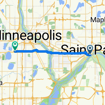
To the River Center
A cycling route starting in Saint Paul, Minnesota, United States.
Overview
About this route
- -:--
- Duration
- 17.1 km
- Distance
- 117 m
- Ascent
- 90 m
- Descent
- ---
- Avg. speed
- ---
- Max. altitude

Continue with Bikemap
Use, edit, or download this cycling route
You would like to ride To the River Center or customize it for your own trip? Here is what you can do with this Bikemap route:
Free features
- Save this route as favorite or in collections
- Copy & plan your own version of this route
- Sync your route with Garmin or Wahoo
Premium features
Free trial for 3 days, or one-time payment. More about Bikemap Premium.
- Navigate this route on iOS & Android
- Export a GPX / KML file of this route
- Create your custom printout (try it for free)
- Download this route for offline navigation
Discover more Premium features.
Get Bikemap PremiumFrom our community
Other popular routes starting in Saint Paul
 River Ramble 20
- Distance
- 29.6 km
- Ascent
- 196 m
- Descent
- 197 m
- Location
- Saint Paul, Minnesota, United States
 B2B00418 55117>55123 via Cedar, Wabasha, Lexington, Pilot Knob Rd
- Distance
- 20.8 km
- Ascent
- 161 m
- Descent
- 156 m
- Location
- Saint Paul, Minnesota, United States
 To the River Center
- Distance
- 17.1 km
- Ascent
- 117 m
- Descent
- 90 m
- Location
- Saint Paul, Minnesota, United States
 B2B00024 55104 > 55121 via Big Rivers Trail
- Distance
- 16.8 km
- Ascent
- 174 m
- Descent
- 174 m
- Location
- Saint Paul, Minnesota, United States
 Como & Phalen Bike Way
- Distance
- 29 km
- Ascent
- 191 m
- Descent
- 191 m
- Location
- Saint Paul, Minnesota, United States
 B2B00368 55102 > 55417 via Shepard Rd, Godfrey, Minnehaha, River Pkwy
- Distance
- 17.8 km
- Ascent
- 96 m
- Descent
- 119 m
- Location
- Saint Paul, Minnesota, United States
 B2B00192 55102>55404viaShepherdRd/MissBlvd/WRiverPkwy/MidtwnGrnway
- Distance
- 21.8 km
- Ascent
- 131 m
- Descent
- 86 m
- Location
- Saint Paul, Minnesota, United States
 Gateway State Trail
- Distance
- 30 km
- Ascent
- 115 m
- Descent
- 69 m
- Location
- Saint Paul, Minnesota, United States
Open it in the app