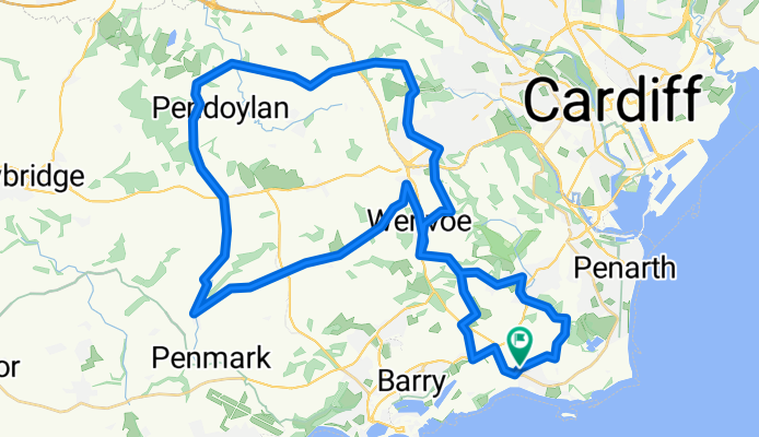
Sully - St Fagans - TreDodridge - Llancarfan - Dinas Powys LOOP
A cycling route starting in Dinas Powys, Wales, United Kingdom.
Overview
About this route
- -:--
- Duration
- 49.7 km
- Distance
- 462 m
- Ascent
- 461 m
- Descent
- ---
- Avg. speed
- ---
- Max. altitude
Route quality
Waytypes & surfaces along the route
Waytypes
Quiet road
25.9 km
(52 %)
Road
17.3 km
(35 %)
Surfaces
Paved
28.6 km
(57 %)
Asphalt
28.6 km
(57 %)
Undefined
21.1 km
(43 %)
Continue with Bikemap
Use, edit, or download this cycling route
You would like to ride Sully - St Fagans - TreDodridge - Llancarfan - Dinas Powys LOOP or customize it for your own trip? Here is what you can do with this Bikemap route:
Free features
- Save this route as favorite or in collections
- Copy & plan your own version of this route
- Sync your route with Garmin or Wahoo
Premium features
Free trial for 3 days, or one-time payment. More about Bikemap Premium.
- Navigate this route on iOS & Android
- Export a GPX / KML file of this route
- Create your custom printout (try it for free)
- Download this route for offline navigation
Discover more Premium features.
Get Bikemap PremiumFrom our community
Other popular routes starting in Dinas Powys
- 35km_Wenvoe-Vale_DesperadosLoop
- Distance
- 35.7 km
- Ascent
- 381 m
- Descent
- 381 m
- Location
- Dinas Powys, Wales, United Kingdom
- 24k_Sully-Dinas-Wenvoe-Cerau-MichLePit-Dinas
- Distance
- 24 km
- Ascent
- 267 m
- Descent
- 267 m
- Location
- Dinas Powys, Wales, United Kingdom
- 68kmSully-LlantwitMajor
- Distance
- 69 km
- Ascent
- 530 m
- Descent
- 530 m
- Location
- Dinas Powys, Wales, United Kingdom
- Sully-Llancarfan-Pontyclun
- Distance
- 35 km
- Ascent
- 400 m
- Descent
- 363 m
- Location
- Dinas Powys, Wales, United Kingdom
- 42km_Pothkerry-Rhoose-Llancarvan-StLythans-Dinas
- Distance
- 42.5 km
- Ascent
- 375 m
- Descent
- 374 m
- Location
- Dinas Powys, Wales, United Kingdom
- 38km loop around StAndrewsMajor+Wenvoe+Penmark
- Distance
- 38 km
- Ascent
- 417 m
- Descent
- 417 m
- Location
- Dinas Powys, Wales, United Kingdom
- Sully - St Fagans - TreDodridge - Llancarfan - Dinas Powys LOOP
- Distance
- 49.7 km
- Ascent
- 462 m
- Descent
- 461 m
- Location
- Dinas Powys, Wales, United Kingdom
- 50km Penmark-StBrides-Michaelston loop
- Distance
- 52.4 km
- Ascent
- 475 m
- Descent
- 473 m
- Location
- Dinas Powys, Wales, United Kingdom
Open it in the app