

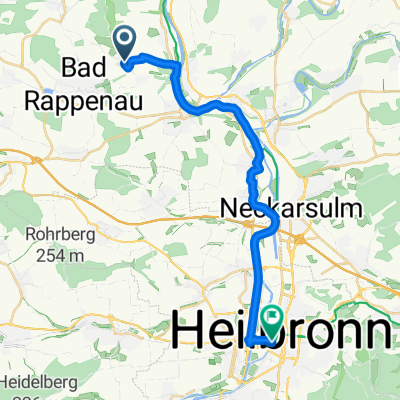
Route im Schneckentempo in Bad Rappenau
A cycling route starting in Bad Rappenau, Baden-Wurttemberg, Germany.
Overview
About this route
- 2 h 52 min
- Duration
- 14.2 km
- Distance
- 738 m
- Ascent
- 747 m
- Descent
- 5 km/h
- Avg. speed
- ---
- Max. altitude

Route quality
Waytypes & surfaces along the route
Waytypes
Track
5.5 km
(39 %)
Pedestrian area
2.4 km
(17 %)
Surfaces
Paved
9.4 km
(66 %)
Unpaved
2.3 km
(16 %)
Asphalt
8.9 km
(63 %)
Loose gravel
1 km
(7 %)
Continue with Bikemap
Use, edit, or download this cycling route
You would like to ride Route im Schneckentempo in Bad Rappenau or customize it for your own trip? Here is what you can do with this Bikemap route:
Free features
- Save this route as favorite or in collections
- Copy & plan your own version of this route
- Sync your route with Garmin or Wahoo
Premium features
Free trial for 3 days, or one-time payment. More about Bikemap Premium.
- Navigate this route on iOS & Android
- Export a GPX / KML file of this route
- Create your custom printout (try it for free)
- Download this route for offline navigation
Discover more Premium features.
Get Bikemap PremiumFrom our community
Other popular routes starting in Bad Rappenau
 Eberbach
- Distance
- 85.4 km
- Ascent
- 1,225 m
- Descent
- 1,269 m
- Location
- Bad Rappenau, Baden-Wurttemberg, Germany
 Rapp_Nbischofsh_Steinsf_Babst
- Distance
- 42.4 km
- Ascent
- 415 m
- Descent
- 416 m
- Location
- Bad Rappenau, Baden-Wurttemberg, Germany
 Rd-BR-Hüffenhardt-N'bischofsh._BR
- Distance
- 37.1 km
- Ascent
- 234 m
- Descent
- 232 m
- Location
- Bad Rappenau, Baden-Wurttemberg, Germany
 Solerundwanderweg
- Distance
- 6.8 km
- Ascent
- 105 m
- Descent
- 105 m
- Location
- Bad Rappenau, Baden-Wurttemberg, Germany
 Ausfahrt vom 24. August 18:35
- Distance
- 21.4 km
- Ascent
- 155 m
- Descent
- 172 m
- Location
- Bad Rappenau, Baden-Wurttemberg, Germany
 Haller Ring nach Götzenturmstraße
- Distance
- 20.8 km
- Ascent
- 175 m
- Descent
- 242 m
- Location
- Bad Rappenau, Baden-Wurttemberg, Germany
 30km Oster Familientour
- Distance
- 29.9 km
- Ascent
- 182 m
- Descent
- 184 m
- Location
- Bad Rappenau, Baden-Wurttemberg, Germany
 Fünfmühlental
- Distance
- 20.3 km
- Ascent
- 173 m
- Descent
- 173 m
- Location
- Bad Rappenau, Baden-Wurttemberg, Germany
Open it in the app