

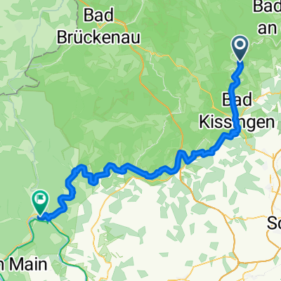
2019-02-17: Bad Bocklet - Münnerstadt
A cycling route starting in Bad Bocklet, Bavaria, Germany.
Overview
About this route
about Bad Neustadt
- -:--
- Duration
- 43.5 km
- Distance
- 282 m
- Ascent
- 278 m
- Descent
- ---
- Avg. speed
- ---
- Max. altitude

Route quality
Waytypes & surfaces along the route
Waytypes
Quiet road
11.3 km
(26 %)
Road
10.4 km
(24 %)
Surfaces
Paved
34.4 km
(79 %)
Unpaved
3 km
(7 %)
Asphalt
33.5 km
(77 %)
Gravel
2.6 km
(6 %)
Continue with Bikemap
Use, edit, or download this cycling route
You would like to ride 2019-02-17: Bad Bocklet - Münnerstadt or customize it for your own trip? Here is what you can do with this Bikemap route:
Free features
- Save this route as favorite or in collections
- Copy & plan your own version of this route
- Sync your route with Garmin or Wahoo
Premium features
Free trial for 3 days, or one-time payment. More about Bikemap Premium.
- Navigate this route on iOS & Android
- Export a GPX / KML file of this route
- Create your custom printout (try it for free)
- Download this route for offline navigation
Discover more Premium features.
Get Bikemap PremiumFrom our community
Other popular routes starting in Bad Bocklet
 Tag 1 2019 - Bad Bocklet/Gemünden
- Distance
- 64.2 km
- Ascent
- 214 m
- Descent
- 278 m
- Location
- Bad Bocklet, Bavaria, Germany
 Aschach - Kreuzberg - Aschach
- Distance
- 55.3 km
- Ascent
- 959 m
- Descent
- 956 m
- Location
- Bad Bocklet, Bavaria, Germany
 Bad Bocklet bis Lohr am Main
- Distance
- 87.2 km
- Ascent
- 262 m
- Descent
- 309 m
- Location
- Bad Bocklet, Bavaria, Germany
 Landkreisumrundung Tag 3 von Steinach nach Oberweisenbrunn
- Distance
- 31.7 km
- Ascent
- 793 m
- Descent
- 422 m
- Location
- Bad Bocklet, Bavaria, Germany
 Rund um den Kreutzberg
- Distance
- 68.6 km
- Ascent
- 1,156 m
- Descent
- 1,147 m
- Location
- Bad Bocklet, Bavaria, Germany
 Bad Bocklet - Waldsassen
- Distance
- 468.3 km
- Ascent
- 1,568 m
- Descent
- 1,573 m
- Location
- Bad Bocklet, Bavaria, Germany
 jakob 1. Etappe windheim - Aub
- Distance
- 117.1 km
- Ascent
- 551 m
- Descent
- 599 m
- Location
- Bad Bocklet, Bavaria, Germany
 Drei-Täler-Tour durch die Südrhön
- Distance
- 25.8 km
- Ascent
- 213 m
- Descent
- 213 m
- Location
- Bad Bocklet, Bavaria, Germany
Open it in the app