
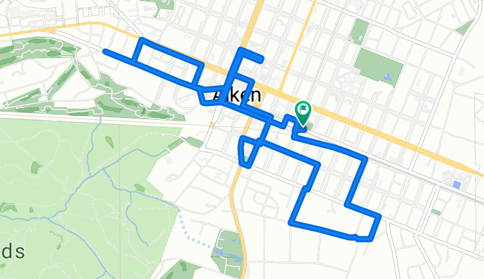
Aiken General Tour Route
A cycling route starting in Aiken, South Carolina, United States.
Overview
About this route
- -:--
- Duration
- 10.9 km
- Distance
- 48 m
- Ascent
- 46 m
- Descent
- ---
- Avg. speed
- ---
- Max. altitude

Route quality
Waytypes & surfaces along the route
Waytypes
Quiet road
6.4 km
(59 %)
Road
3.6 km
(33 %)
Undefined
0.9 km
(8 %)
Surfaces
Unpaved
0.7 km
(6 %)
Ground
0.7 km
(6 %)
Undefined
10.2 km
(94 %)
Route highlights
Points of interest along the route
Point of interest after 0 km
Caboose
Point of interest after 0 km
Start
Point of interest after 0.4 km
Aiken Cut
Point of interest after 0.9 km
Aiken Train Station
Point of interest after 1.5 km
Tree Tunnel
Point of interest after 2.3 km
Cool House
Point of interest after 2.5 km
Whitney Polo Field
Point of interest after 4.2 km
Aiken Institute
Point of interest after 4.8 km
Old St Marry's
Point of interest after 5.1 km
Newberry St
Point of interest after 5.2 km
St John's
Point of interest after 7.3 km
Old Hospital
Point of interest after 7.9 km
St Thadius
Point of interest after 8.4 km
Old Post Office
Point of interest after 10.6 km
St Marry's Cathedrial
Point of interest after 10.7 km
Aiken Train Museum
Continue with Bikemap
Use, edit, or download this cycling route
You would like to ride Aiken General Tour Route or customize it for your own trip? Here is what you can do with this Bikemap route:
Free features
- Save this route as favorite or in collections
- Copy & plan your own version of this route
- Sync your route with Garmin or Wahoo
Premium features
Free trial for 3 days, or one-time payment. More about Bikemap Premium.
- Navigate this route on iOS & Android
- Export a GPX / KML file of this route
- Create your custom printout (try it for free)
- Download this route for offline navigation
Discover more Premium features.
Get Bikemap PremiumFrom our community
Other popular routes starting in Aiken
 164 Weaver St, Aiken to 116–184 Fore St, Aiken
- Distance
- 8.5 km
- Ascent
- 53 m
- Descent
- 60 m
- Location
- Aiken, South Carolina, United States
 aiken
aiken- Distance
- 65.1 km
- Ascent
- 611 m
- Descent
- 622 m
- Location
- Aiken, South Carolina, United States
 Greenville Street Southwest 127, Aiken to Rico Lane 515, Aiken
- Distance
- 5.1 km
- Ascent
- 22 m
- Descent
- 25 m
- Location
- Aiken, South Carolina, United States
 Barry Johnson Blvd, Aiken to Barry Johnson Blvd, Aiken
- Distance
- 16 km
- Ascent
- 23 m
- Descent
- 22 m
- Location
- Aiken, South Carolina, United States
 MH-Aiken DT
- Distance
- 8.7 km
- Ascent
- 11 m
- Descent
- 7 m
- Location
- Aiken, South Carolina, United States
 23 Erskine Ln, Aiken to 344–416 Boyd Pond Rd, Aiken
- Distance
- 15.8 km
- Ascent
- 59 m
- Descent
- 127 m
- Location
- Aiken, South Carolina, United States
 866 York St NE, Aiken to 106 Trenton Ln, Aiken
- Distance
- 3.1 km
- Ascent
- 6 m
- Descent
- 9 m
- Location
- Aiken, South Carolina, United States
 East Pine Log Road 129, Aiken to East Pine Log Road 129, Aiken
- Distance
- 46.2 km
- Ascent
- 217 m
- Descent
- 255 m
- Location
- Aiken, South Carolina, United States
Open it in the app