

Hochsteinberg-GeheimtippRunde
A cycling route starting in Mank, Lower Austria, Austria.
Overview
About this route
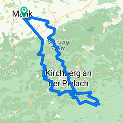
Mank - Hochsteinberg - Texing - Hochsteinberg - Mank
- -:--
- Duration
- 26.2 km
- Distance
- 613 m
- Ascent
- 610 m
- Descent
- ---
- Avg. speed
- ---
- Max. altitude

Continue with Bikemap
Use, edit, or download this cycling route
You would like to ride Hochsteinberg-GeheimtippRunde or customize it for your own trip? Here is what you can do with this Bikemap route:
Free features
- Save this route as favorite or in collections
- Copy & plan your own version of this route
- Sync your route with Garmin or Wahoo
Premium features
Free trial for 3 days, or one-time payment. More about Bikemap Premium.
- Navigate this route on iOS & Android
- Export a GPX / KML file of this route
- Create your custom printout (try it for free)
- Download this route for offline navigation
Discover more Premium features.
Get Bikemap PremiumFrom our community
Other popular routes starting in Mank
 Oberndorfer Höhe-Texinger Berg
- Distance
- 42.2 km
- Ascent
- 690 m
- Descent
- 690 m
- Location
- Mank, Lower Austria, Austria
 Schöngrabenrunde
- Distance
- 54.8 km
- Ascent
- 1,825 m
- Descent
- 1,826 m
- Location
- Mank, Lower Austria, Austria
 Hochsteinberg-GeheimtippRunde
- Distance
- 26.2 km
- Ascent
- 613 m
- Descent
- 610 m
- Location
- Mank, Lower Austria, Austria
 Mank-Hofstetten-Mank
- Distance
- 49.2 km
- Ascent
- 825 m
- Descent
- 825 m
- Location
- Mank, Lower Austria, Austria
 Mank - Texingtal - Mank
- Distance
- 25.2 km
- Ascent
- 380 m
- Descent
- 380 m
- Location
- Mank, Lower Austria, Austria
 NÖ Achter
- Distance
- 147.8 km
- Ascent
- 986 m
- Descent
- 985 m
- Location
- Mank, Lower Austria, Austria
 AustriaTour_czI - Mank-Villach
- Distance
- 569 km
- Ascent
- 3,252 m
- Descent
- 3,052 m
- Location
- Mank, Lower Austria, Austria
 Flache Runde
- Distance
- 73.9 km
- Ascent
- 1,072 m
- Descent
- 1,080 m
- Location
- Mank, Lower Austria, Austria
Open it in the app