

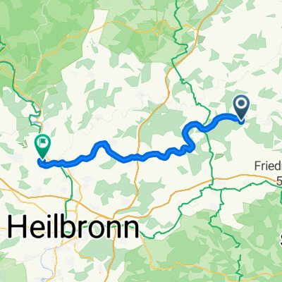
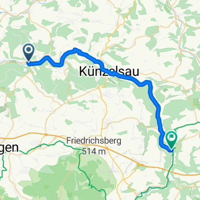
Kocher-Jagst3, Forcht-berg-Bad Friedr.hall
A cycling route starting in Forchtenberg, Baden-Wurttemberg, Germany.
Overview
About this route
- -:--
- Duration
- 37.7 km
- Distance
- 84 m
- Ascent
- 120 m
- Descent
- ---
- Avg. speed
- ---
- Max. altitude

Route quality
Waytypes & surfaces along the route
Waytypes
Track
14.7 km
(39 %)
Path
13.2 km
(35 %)
Surfaces
Paved
36.1 km
(96 %)
Unpaved
1.1 km
(3 %)
Asphalt
32.8 km
(87 %)
Concrete
3.4 km
(9 %)
Continue with Bikemap
Use, edit, or download this cycling route
You would like to ride Kocher-Jagst3, Forcht-berg-Bad Friedr.hall or customize it for your own trip? Here is what you can do with this Bikemap route:
Free features
- Save this route as favorite or in collections
- Copy & plan your own version of this route
- Sync your route with Garmin or Wahoo
Premium features
Free trial for 3 days, or one-time payment. More about Bikemap Premium.
- Navigate this route on iOS & Android
- Export a GPX / KML file of this route
- Create your custom printout (try it for free)
- Download this route for offline navigation
Discover more Premium features.
Get Bikemap PremiumFrom our community
Other popular routes starting in Forchtenberg
 Ernsbach, Klosterwald, Hohe Straße, Bobachshof, Crispenhofen, Weißbach, Büschelfof, Forchtenberg
- Distance
- 38.4 km
- Ascent
- 595 m
- Descent
- 593 m
- Location
- Forchtenberg, Baden-Wurttemberg, Germany
 Forchtenberg - Bad Wimpfen 43km
- Distance
- 42.7 km
- Ascent
- 409 m
- Descent
- 413 m
- Location
- Forchtenberg, Baden-Wurttemberg, Germany
 von Ernsbach über Hohe Straße ins Sindelbachtal und zurück über Tiroler Seen
- Distance
- 39.5 km
- Ascent
- 544 m
- Descent
- 534 m
- Location
- Forchtenberg, Baden-Wurttemberg, Germany
 Mühlweg, Forchtenberg nach Döttinger Straße, Braunsbach
- Distance
- 28.5 km
- Ascent
- 535 m
- Descent
- 481 m
- Location
- Forchtenberg, Baden-Wurttemberg, Germany
 Trainingsrunde Kochertalexpress
- Distance
- 39.9 km
- Ascent
- 522 m
- Descent
- 522 m
- Location
- Forchtenberg, Baden-Wurttemberg, Germany
 vom Kochertal durch Hardthäuser Wald nach Widdern und über Jagsthausen zurück
- Distance
- 30.6 km
- Ascent
- 426 m
- Descent
- 402 m
- Location
- Forchtenberg, Baden-Wurttemberg, Germany
 Von Ernsbach über Westernhausen Richtung Bieringen und vom Kloster Schöntal zurück
- Distance
- 37.4 km
- Ascent
- 621 m
- Descent
- 617 m
- Location
- Forchtenberg, Baden-Wurttemberg, Germany
 Kocher-Jagst3, Forcht-berg-Bad Friedr.hall
- Distance
- 37.7 km
- Ascent
- 84 m
- Descent
- 120 m
- Location
- Forchtenberg, Baden-Wurttemberg, Germany
Open it in the app