

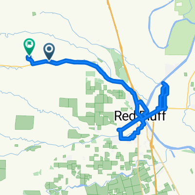
Lyric Slaughter
A cycling route starting in Red Bluff, California, United States.
Overview
About this route
- -:--
- Duration
- 20.7 km
- Distance
- 135 m
- Ascent
- 98 m
- Descent
- ---
- Avg. speed
- ---
- Max. altitude
Route quality
Waytypes & surfaces along the route
Waytypes
Road
14.1 km
(68 %)
Quiet road
3.5 km
(17 %)
Surfaces
Paved
13.5 km
(65 %)
Asphalt
13.5 km
(65 %)
Undefined
7.3 km
(35 %)
Route highlights
Points of interest along the route
Point of interest after 1.7 km
Point of interest after 3.3 km
Point of interest after 7.1 km
Continue with Bikemap
Use, edit, or download this cycling route
You would like to ride Lyric Slaughter or customize it for your own trip? Here is what you can do with this Bikemap route:
Free features
- Save this route as favorite or in collections
- Copy & plan your own version of this route
- Sync your route with Garmin or Wahoo
Premium features
Free trial for 3 days, or one-time payment. More about Bikemap Premium.
- Navigate this route on iOS & Android
- Export a GPX / KML file of this route
- Create your custom printout (try it for free)
- Download this route for offline navigation
Discover more Premium features.
Get Bikemap PremiumFrom our community
Other popular routes starting in Red Bluff
 Red Bluff - Willows
- Distance
- 284.7 km
- Ascent
- 298 m
- Descent
- 329 m
- Location
- Red Bluff, California, United States
 Lyric Slaughter
- Distance
- 20.7 km
- Ascent
- 135 m
- Descent
- 98 m
- Location
- Red Bluff, California, United States
 SS 2011 day2
- Distance
- 88 km
- Ascent
- 1,071 m
- Descent
- 348 m
- Location
- Red Bluff, California, United States
 Red Bluff - Williams
- Distance
- 117.7 km
- Ascent
- 46 m
- Descent
- 108 m
- Location
- Red Bluff, California, United States
 lassen-lassen
- Distance
- 223.5 km
- Ascent
- 4,165 m
- Descent
- 1,728 m
- Location
- Red Bluff, California, United States
 Slow ride
- Distance
- 50 km
- Ascent
- 530 m
- Descent
- 508 m
- Location
- Red Bluff, California, United States
 Slow ride
- Distance
- 22.2 km
- Ascent
- 145 m
- Descent
- 65 m
- Location
- Red Bluff, California, United States
 10 Red.Bluff - Sacramento
- Distance
- 222.2 km
- Ascent
- 54 m
- Descent
- 132 m
- Location
- Red Bluff, California, United States
Open it in the app