
Holland 2019
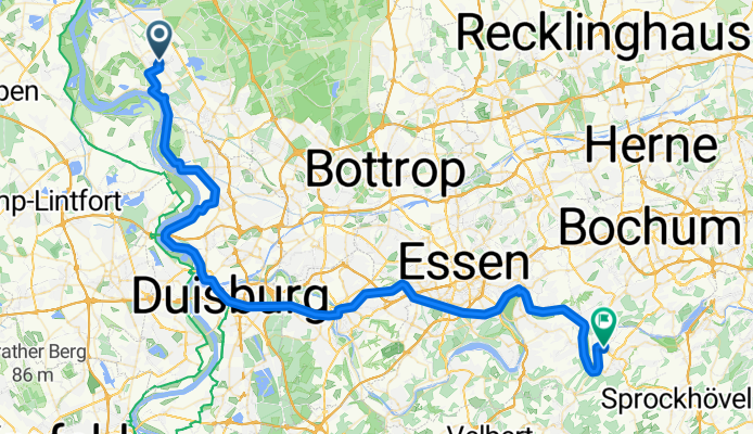
Voerde-Hattingen Vario 4
A cycling route starting in Voerde, North Rhine-Westphalia, Germany.
Overview
About this route
- -:--
- Duration
- 67.7 km
- Distance
- 200 m
- Ascent
- 159 m
- Descent
- ---
- Avg. speed
- ---
- Max. altitude

Part of
Holland 2019
10 stages
Route quality
Waytypes & surfaces along the route
Waytypes
Path
38.6 km
(57 %)
Cycleway
8.1 km
(12 %)
Surfaces
Paved
34.5 km
(51 %)
Unpaved
14.9 km
(22 %)
Asphalt
33.8 km
(50 %)
Gravel
14.2 km
(21 %)
Continue with Bikemap
Use, edit, or download this cycling route
You would like to ride Voerde-Hattingen Vario 4 or customize it for your own trip? Here is what you can do with this Bikemap route:
Free features
- Save this route as favorite or in collections
- Copy & plan your own version of this route
- Sync your route with Garmin or Wahoo
Premium features
Free trial for 3 days, or one-time payment. More about Bikemap Premium.
- Navigate this route on iOS & Android
- Export a GPX / KML file of this route
- Create your custom printout (try it for free)
- Download this route for offline navigation
Discover more Premium features.
Get Bikemap PremiumFrom our community
Other popular routes starting in Voerde
 Mühlenbach - Tester Berge
- Distance
- 28.6 km
- Ascent
- 94 m
- Descent
- 96 m
- Location
- Voerde, North Rhine-Westphalia, Germany
 Keer Tröch
- Distance
- 35.5 km
- Ascent
- 55 m
- Descent
- 55 m
- Location
- Voerde, North Rhine-Westphalia, Germany
 Kronprinzenstraße 37, Voerde (Niederrhein) nach Kronprinzenstraße 15, Voerde (Niederrhein)
- Distance
- 49 km
- Ascent
- 232 m
- Descent
- 235 m
- Location
- Voerde, North Rhine-Westphalia, Germany
 Kleine Abendrunde
- Distance
- 41.9 km
- Ascent
- 89 m
- Descent
- 90 m
- Location
- Voerde, North Rhine-Westphalia, Germany
 Parkstraße 11, Voerde (Niederrhein) nach Parkstraße 11, Voerde (Niederrhein)
- Distance
- 29.2 km
- Ascent
- 46 m
- Descent
- 90 m
- Location
- Voerde, North Rhine-Westphalia, Germany
 Feierabendrunde entlang des Rheins über Wesel anschließend Lippefähre
- Distance
- 29.2 km
- Ascent
- 3 m
- Descent
- 24 m
- Location
- Voerde, North Rhine-Westphalia, Germany
 Parkstraße 11, Voerde (Niederrhein) nach Parkstraße 11, Voerde (Niederrhein)
- Distance
- 32.9 km
- Ascent
- 40 m
- Descent
- 85 m
- Location
- Voerde, North Rhine-Westphalia, Germany
 Standardrunde ca. 30km
- Distance
- 29.2 km
- Ascent
- 65 m
- Descent
- 68 m
- Location
- Voerde, North Rhine-Westphalia, Germany
Open it in the app