
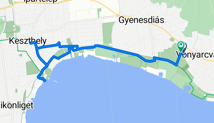
Gyenesdias-Keszthely
A cycling route starting in Vonyarcvashegy, Zala County, Hungary.
Overview
About this route
- -:--
- Duration
- 11.4 km
- Distance
- 20 m
- Ascent
- 22 m
- Descent
- ---
- Avg. speed
- ---
- Max. altitude

Route quality
Waytypes & surfaces along the route
Waytypes
Cycleway
5.1 km
(45 %)
Quiet road
3.9 km
(34 %)
Surfaces
Paved
8.6 km
(75 %)
Unpaved
0.3 km
(3 %)
Asphalt
8.6 km
(75 %)
Unpaved (undefined)
0.3 km
(3 %)
Undefined
2.5 km
(22 %)
Continue with Bikemap
Use, edit, or download this cycling route
You would like to ride Gyenesdias-Keszthely or customize it for your own trip? Here is what you can do with this Bikemap route:
Free features
- Save this route as favorite or in collections
- Copy & plan your own version of this route
- Sync your route with Garmin or Wahoo
Premium features
Free trial for 3 days, or one-time payment. More about Bikemap Premium.
- Navigate this route on iOS & Android
- Export a GPX / KML file of this route
- Create your custom printout (try it for free)
- Download this route for offline navigation
Discover more Premium features.
Get Bikemap PremiumFrom our community
Other popular routes starting in Vonyarcvashegy
 Eresztényi út, Balatongyörök - Eresztényi út, Balatongyörök
- Distance
- 40.8 km
- Ascent
- 233 m
- Descent
- 232 m
- Location
- Vonyarcvashegy, Zala County, Hungary
 Rund um den Plattensee
- Distance
- 202.6 km
- Ascent
- 208 m
- Descent
- 212 m
- Location
- Vonyarcvashegy, Zala County, Hungary
 Vonyarc.-Sümeg.-Vonyarc.
- Distance
- 78.9 km
- Ascent
- 399 m
- Descent
- 400 m
- Location
- Vonyarcvashegy, Zala County, Hungary
 Balatoni keringő
- Distance
- 142.2 km
- Ascent
- 122 m
- Descent
- 122 m
- Location
- Vonyarcvashegy, Zala County, Hungary
 Déli-Bakony kör / Balatongyörök - Kab-hegy - Ajka - Balatongyörök
- Distance
- 131.2 km
- Ascent
- 830 m
- Descent
- 828 m
- Location
- Vonyarcvashegy, Zala County, Hungary
 Balatongyörök - Fonyód - Badacsony - Balatongyörök
- Distance
- 69.7 km
- Ascent
- 71 m
- Descent
- 69 m
- Location
- Vonyarcvashegy, Zala County, Hungary
 2023 VIP Balaton Tour Day 6
- Distance
- 39.5 km
- Ascent
- 96 m
- Descent
- 61 m
- Location
- Vonyarcvashegy, Zala County, Hungary
 Gyenesdias-Keszthely
- Distance
- 11.4 km
- Ascent
- 20 m
- Descent
- 22 m
- Location
- Vonyarcvashegy, Zala County, Hungary
Open it in the app