
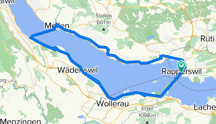
Halber Zürichsee
A cycling route starting in Rapperswil, Canton of St. Gallen, Switzerland.
Overview
About this route
Einige Wege sind nur Teils befahrbar.
Seeuferweg zwischen Giessen und Jugendherberge Richterswil ist befahrbar und muss nicht via Hauptstrasse gefahren werden! Das Selbe gilt für den Weg Vis a Vis des Seeweges bei der Seeanlage Freienbach.
Der Weg von Meilen nach Horgen muss mit der Fähre absolviert werden. Kosten 4.50 CHF
Gesammte Distanz: ca. 43 Km
- -:--
- Duration
- 47.8 km
- Distance
- 108 m
- Ascent
- 111 m
- Descent
- ---
- Avg. speed
- ---
- Avg. speed
Route quality
Waytypes & surfaces along the route
Waytypes
Quiet road
20.9 km
(44 %)
Pedestrian area
9.2 km
(19 %)
Surfaces
Paved
34.6 km
(72 %)
Unpaved
7.5 km
(16 %)
Asphalt
32.3 km
(67 %)
Loose gravel
4.8 km
(10 %)
Continue with Bikemap
Use, edit, or download this cycling route
You would like to ride Halber Zürichsee or customize it for your own trip? Here is what you can do with this Bikemap route:
Free features
- Save this route as favorite or in collections
- Copy & plan your own version of this route
- Sync your route with Garmin or Wahoo
Premium features
Free trial for 3 days, or one-time payment. More about Bikemap Premium.
- Navigate this route on iOS & Android
- Export a GPX / KML file of this route
- Create your custom printout (try it for free)
- Download this route for offline navigation
Discover more Premium features.
Get Bikemap PremiumFrom our community
Other popular routes starting in Rapperswil
 Walensee-Rheintal-Appenzell
- Distance
- 174.7 km
- Ascent
- 1,275 m
- Descent
- 1,270 m
- Location
- Rapperswil, Canton of St. Gallen, Switzerland
 Day 4: Queens Stage
- Distance
- 94.8 km
- Ascent
- 0 m
- Descent
- 0 m
- Location
- Rapperswil, Canton of St. Gallen, Switzerland
 Sattelegg - Ibergeregg - Zugersee
- Distance
- 117.9 km
- Ascent
- 1,857 m
- Descent
- 1,858 m
- Location
- Rapperswil, Canton of St. Gallen, Switzerland
 Rapperswil-Sass da Grüm
- Distance
- 270.6 km
- Ascent
- 2,119 m
- Descent
- 2,064 m
- Location
- Rapperswil, Canton of St. Gallen, Switzerland
 Schönbodenweg 54, Rapperswil-Jona nach Schönbodenweg 54, Rapperswil-Jona
- Distance
- 31.3 km
- Ascent
- 321 m
- Descent
- 320 m
- Location
- Rapperswil, Canton of St. Gallen, Switzerland
 Schönbodenstrasse 56, Rapperswil-Jona nach Schönbodenstrasse 56, Rapperswil-Jona
- Distance
- 38.5 km
- Ascent
- 293 m
- Descent
- 293 m
- Location
- Rapperswil, Canton of St. Gallen, Switzerland
 Rapperswil-Jona nach Rhein (Zweidlen). Neu: "Geheimer" Gleisweg Eglisau - Zweidlen (eine Verlängerung in den Schatten). Achtung: Beim Hochwasser: überflütet
- Distance
- 67.2 km
- Ascent
- 749 m
- Descent
- 803 m
- Location
- Rapperswil, Canton of St. Gallen, Switzerland
 Rund um die Rigi
- Distance
- 119.8 km
- Ascent
- 1,070 m
- Descent
- 1,067 m
- Location
- Rapperswil, Canton of St. Gallen, Switzerland
Open it in the app