

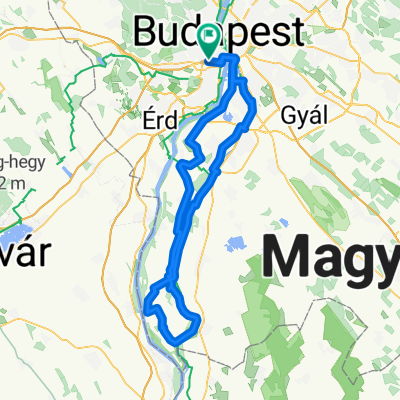
Budapest - Balatonfenyves
A cycling route starting in Újbuda, Budapest, Hungary.
Overview
About this route
7-es úton szinte végig alacsony a forgalom, pedig július elején szombaton volt a túra. A kamionstop miatt ajánlatos tehát hétvégén menni a 7-esen.
A bringagyász használhatatlan (1-2hely kivételével, ott viszont át kéne tolni az út túloldalára a bringát).
Többnyire sík az út, de helyenkén van jó pár hosszú emelkedő/lejtő.
A székesfehérvári kitérő a Sóstó-ipari parkba hanyagolandó (hacsak nem bevásárlás a cél), mivel utána a 8-as autóútra visz az út, hogy legrövidebben visszatérjünk a 7-esre.
Az út minősége változó, ahol régen kész van az M7-es ott rosszabb.
Kellemes túra, 10 óra alatt kényelmes, 20-25-ös tempóval teljesíthető.
- -:--
- Duration
- 161.9 km
- Distance
- 419 m
- Ascent
- 420 m
- Descent
- ---
- Avg. speed
- ---
- Max. altitude

Route highlights
Points of interest along the route
Point of interest after 74.3 km
javasolt út a kitérő helyett (bevásárlóközpont miatt volt kitérő)
Continue with Bikemap
Use, edit, or download this cycling route
You would like to ride Budapest - Balatonfenyves or customize it for your own trip? Here is what you can do with this Bikemap route:
Free features
- Save this route as favorite or in collections
- Copy & plan your own version of this route
- Split it into stages to create a multi-day tour
- Sync your route with Garmin or Wahoo
Premium features
Free trial for 3 days, or one-time payment. More about Bikemap Premium.
- Navigate this route on iOS & Android
- Export a GPX / KML file of this route
- Create your custom printout (try it for free)
- Download this route for offline navigation
Discover more Premium features.
Get Bikemap PremiumFrom our community
Other popular routes starting in Újbuda
 buda fincsi emelkedői selection
- Distance
- 48.9 km
- Ascent
- 1,273 m
- Descent
- 920 m
- Location
- Újbuda, Budapest, Hungary
 normafabudaörs ünnepi
- Distance
- 32.6 km
- Ascent
- 511 m
- Descent
- 512 m
- Location
- Újbuda, Budapest, Hungary
 Csepel 60
- Distance
- 60.3 km
- Ascent
- 178 m
- Descent
- 180 m
- Location
- Újbuda, Budapest, Hungary
 Budapest to Szentendre
- Distance
- 78 km
- Ascent
- 868 m
- Descent
- 867 m
- Location
- Újbuda, Budapest, Hungary
 Csepel sziget túra a Magyar Kerékpárosklubbal
- Distance
- 129.1 km
- Ascent
- 32 m
- Descent
- 31 m
- Location
- Újbuda, Budapest, Hungary
 Budapest - Balatonfenyves
- Distance
- 161.9 km
- Ascent
- 419 m
- Descent
- 420 m
- Location
- Újbuda, Budapest, Hungary
 Kopaszigát - Érd - Diósd - Törökbálint - Kopaszigát
- Distance
- 48.2 km
- Ascent
- 257 m
- Descent
- 261 m
- Location
- Újbuda, Budapest, Hungary
 csillaghegy-rókahegy-csobánka-lajosforrás-fagyoskatona-pilisszentkereszt-piros-nagykovácsi-hűvösvölgy
- Distance
- 81.1 km
- Ascent
- 1,159 m
- Descent
- 1,160 m
- Location
- Újbuda, Budapest, Hungary
Open it in the app