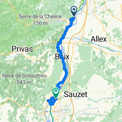
dernière ligne droite
A cycling route starting in Beauchastel, Auvergne-Rhône-Alpes, France.
Overview
About this route
- -:--
- Duration
- 17.4 km
- Distance
- 349 m
- Ascent
- 38 m
- Descent
- ---
- Avg. speed
- ---
- Avg. speed
Route quality
Waytypes & surfaces along the route
Waytypes
Path
7.2 km
(42 %)
Road
4.5 km
(26 %)
Surfaces
Paved
1.1 km
(7 %)
Unpaved
7.7 km
(44 %)
Gravel
7.7 km
(44 %)
Asphalt
1.1 km
(7 %)
Continue with Bikemap
Use, edit, or download this cycling route
You would like to ride dernière ligne droite or customize it for your own trip? Here is what you can do with this Bikemap route:
Free features
- Save this route as favorite or in collections
- Copy & plan your own version of this route
- Sync your route with Garmin or Wahoo
Premium features
Free trial for 3 days, or one-time payment. More about Bikemap Premium.
- Navigate this route on iOS & Android
- Export a GPX / KML file of this route
- Create your custom printout (try it for free)
- Download this route for offline navigation
Discover more Premium features.
Get Bikemap PremiumFrom our community
Other popular routes starting in Beauchastel
- Szprycha wzdłuż Rodanu do Lazurowego Wybrzeża - 10.07.2016 r.
- Distance
- 37.3 km
- Ascent
- 83 m
- Descent
- 106 m
- Location
- Beauchastel, Auvergne-Rhône-Alpes, France
- 6 Route du Pont, Beauchastel naar 1 Chemin des Sportifs, Soyons
- Distance
- 12.8 km
- Ascent
- 69 m
- Descent
- 59 m
- Location
- Beauchastel, Auvergne-Rhône-Alpes, France
- dernière ligne droite
- Distance
- 17.4 km
- Ascent
- 349 m
- Descent
- 38 m
- Location
- Beauchastel, Auvergne-Rhône-Alpes, France
- Via Rhona, Beauchastel nach Chemin de la Payré, Baix
- Distance
- 16.1 km
- Ascent
- 61 m
- Descent
- 78 m
- Location
- Beauchastel, Auvergne-Rhône-Alpes, France
- VB to Olières
- Distance
- 17.9 km
- Ascent
- 173 m
- Descent
- 69 m
- Location
- Beauchastel, Auvergne-Rhône-Alpes, France
- Beauchastel - Pont-Saint-Esprit
- Distance
- 81.5 km
- Ascent
- 145 m
- Descent
- 194 m
- Location
- Beauchastel, Auvergne-Rhône-Alpes, France
- Höllentrip ans Ende Europas 1150-1500km
- Distance
- 350 km
- Ascent
- 206 m
- Descent
- 268 m
- Location
- Beauchastel, Auvergne-Rhône-Alpes, France
- La Voulte - Le Puy
- Distance
- 127 km
- Ascent
- 1,652 m
- Descent
- 1,155 m
- Location
- Beauchastel, Auvergne-Rhône-Alpes, France
Open it in the app