

Csarda túra MTB 55
A cycling route starting in Komárno, Nitriansky kraj, Slovak Republic.
Overview
About this route
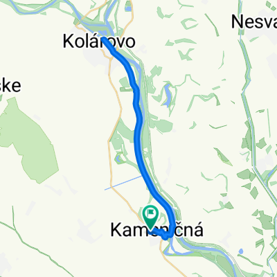
Komárom - Izsa - Pat - Zsitvatő - Szilos - Marcelháza - Hetény - Gyulamajor - Komárom.
Szintkülönbség: 110 méter, szintidő: 6 óra. Komárno - Iža - Patince - Zitava - Šrobárová - Marcelová - Chotín - Ďulov Dvor - Komárno Prevýšenie: 110 metrov, max. doba: 6 hodín- -:--
- Duration
- 53.4 km
- Distance
- 137 m
- Ascent
- 138 m
- Descent
- ---
- Avg. speed
- ---
- Avg. speed

Route highlights
Points of interest along the route
Point of interest after 1.9 km
1P
Point of interest after 11.3 km
P2
Point of interest after 16.5 km
P3
Point of interest after 23.7 km
4P
Point of interest after 32 km
5P
Point of interest after 36.1 km
6P
Point of interest after 46.9 km
7P
Continue with Bikemap
Use, edit, or download this cycling route
You would like to ride Csarda túra MTB 55 or customize it for your own trip? Here is what you can do with this Bikemap route:
Free features
- Save this route as favorite or in collections
- Copy & plan your own version of this route
- Sync your route with Garmin or Wahoo
Premium features
Free trial for 3 days, or one-time payment. More about Bikemap Premium.
- Navigate this route on iOS & Android
- Export a GPX / KML file of this route
- Create your custom printout (try it for free)
- Download this route for offline navigation
Discover more Premium features.
Get Bikemap PremiumFrom our community
Other popular routes starting in Komárno
 Csarda Túra EXTREME 110km
- Distance
- 107.7 km
- Ascent
- 245 m
- Descent
- 248 m
- Location
- Komárno, Nitriansky kraj, Slovak Republic
 Csarda túra MTB 55
- Distance
- 53.4 km
- Ascent
- 137 m
- Descent
- 138 m
- Location
- Komárno, Nitriansky kraj, Slovak Republic
 13.Etappe
- Distance
- 74.3 km
- Ascent
- 69 m
- Descent
- 59 m
- Location
- Komárno, Nitriansky kraj, Slovak Republic
 PBM - MTB56
- Distance
- 54 km
- Ascent
- 15 m
- Descent
- 18 m
- Location
- Komárno, Nitriansky kraj, Slovak Republic
 Kameničná, Keszegfalva - Kameničná, Keszegfalva
- Distance
- 29.1 km
- Ascent
- 38 m
- Descent
- 36 m
- Location
- Komárno, Nitriansky kraj, Slovak Republic
 Csarda túra MTB 55
- Distance
- 53.4 km
- Ascent
- 137 m
- Descent
- 138 m
- Location
- Komárno, Nitriansky kraj, Slovak Republic
 KN-Komárom- Dunaalmás- Nezmély- Süttő (HU)
- Distance
- 28.3 km
- Ascent
- 55 m
- Descent
- 50 m
- Location
- Komárno, Nitriansky kraj, Slovak Republic
 KidCup - MINI + BABY
- Distance
- 0.5 km
- Ascent
- 0 m
- Descent
- 5 m
- Location
- Komárno, Nitriansky kraj, Slovak Republic
Open it in the app