

Versuch aufs Rifugio de Maria
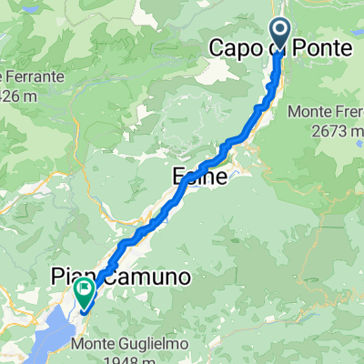
A cycling route starting in Capo di Ponte, Lombardy, Italy.
Overview
About this route
Wichtig, in der zweiten Kurve (Bar) geht der Abzweig zum Rifugio eigentlich weg. Teils schattige Tour mit Brunnen zur Wasserversorgung. Mehr kann ich leider nicht sagen. Rückweg ist wie der Hinweg.
- 2 h 30 min
- Duration
- 24 km
- Distance
- 1,010 m
- Ascent
- 1,006 m
- Descent
- 9.6 km/h
- Avg. speed
- ---
- Max. altitude

Route photos


Continue with Bikemap
Use, edit, or download this cycling route
You would like to ride Versuch aufs Rifugio de Maria or customize it for your own trip? Here is what you can do with this Bikemap route:
Free features
- Save this route as favorite or in collections
- Copy & plan your own version of this route
- Sync your route with Garmin or Wahoo
Premium features
Free trial for 3 days, or one-time payment. More about Bikemap Premium.
- Navigate this route on iOS & Android
- Export a GPX / KML file of this route
- Create your custom printout (try it for free)
- Download this route for offline navigation
Discover more Premium features.
Get Bikemap PremiumFrom our community
Other popular routes starting in Capo di Ponte
 6. Capo die Ponte-Storo(Albergo Firi)
- Distance
- 75.1 km
- Ascent
- 1,928 m
- Descent
- 1,911 m
- Location
- Capo di Ponte, Lombardy, Italy
 20 Sept - to Iseo-F
- Distance
- 61.3 km
- Ascent
- 252 m
- Descent
- 446 m
- Location
- Capo di Ponte, Lombardy, Italy
 Capo di Ponte - Pisogne
- Distance
- 37.8 km
- Ascent
- 17 m
- Descent
- 201 m
- Location
- Capo di Ponte, Lombardy, Italy
 Versuch aufs Rifugio de Maria
- Distance
- 24 km
- Ascent
- 1,010 m
- Descent
- 1,006 m
- Location
- Capo di Ponte, Lombardy, Italy
 Capo di Ponte - Nadro -Cimbergo - Rifugio Volano de Marie
- Distance
- 26.7 km
- Ascent
- 1,075 m
- Descent
- 1,073 m
- Location
- Capo di Ponte, Lombardy, Italy
 capo di ponte pisogne tv
- Distance
- 39.5 km
- Ascent
- 162 m
- Descent
- 350 m
- Location
- Capo di Ponte, Lombardy, Italy
 capo/paspardo/capo
- Distance
- 18.8 km
- Ascent
- 653 m
- Descent
- 655 m
- Location
- Capo di Ponte, Lombardy, Italy
 mortirolo
- Distance
- 91.1 km
- Ascent
- 2,206 m
- Descent
- 2,203 m
- Location
- Capo di Ponte, Lombardy, Italy
Open it in the app