

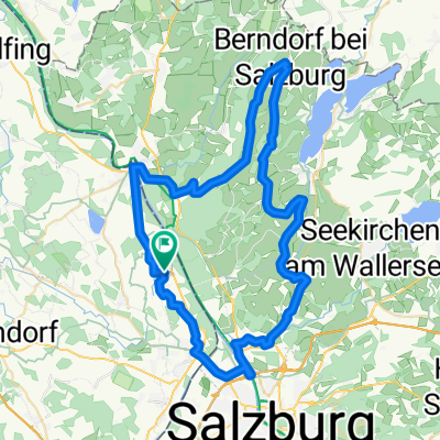
Haunsberg-Högl-Runde
A cycling route starting in Anthering, Salzburg, Austria.
Overview
About this route
<p>Haunsberg - Voggenberg - Plain - Högl</p>
Translated, show original (German)- -:--
- Duration
- 86.1 km
- Distance
- 984 m
- Ascent
- 984 m
- Descent
- ---
- Avg. speed
- ---
- Max. altitude

Route quality
Waytypes & surfaces along the route
Waytypes
Quiet road
38.7 km
(45 %)
Road
18.1 km
(21 %)
Surfaces
Paved
53.4 km
(62 %)
Unpaved
10.3 km
(12 %)
Asphalt
53.4 km
(62 %)
Gravel
6.9 km
(8 %)
Continue with Bikemap
Use, edit, or download this cycling route
You would like to ride Haunsberg-Högl-Runde or customize it for your own trip? Here is what you can do with this Bikemap route:
Free features
- Save this route as favorite or in collections
- Copy & plan your own version of this route
- Split it into stages to create a multi-day tour
- Sync your route with Garmin or Wahoo
Premium features
Free trial for 3 days, or one-time payment. More about Bikemap Premium.
- Navigate this route on iOS & Android
- Export a GPX / KML file of this route
- Create your custom printout (try it for free)
- Download this route for offline navigation
Discover more Premium features.
Get Bikemap PremiumFrom our community
Other popular routes starting in Anthering
 Haunsbergrunde
- Distance
- 32.8 km
- Ascent
- 454 m
- Descent
- 435 m
- Location
- Anthering, Salzburg, Austria
 Himmelreich - Haunsberg - Berndorf - Elixhausen - Salzburg - Himmelreich
- Distance
- 64.2 km
- Ascent
- 669 m
- Descent
- 664 m
- Location
- Anthering, Salzburg, Austria
 Seenrunde
- Distance
- 63.9 km
- Ascent
- 477 m
- Descent
- 477 m
- Location
- Anthering, Salzburg, Austria
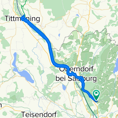 Anthering an der Salzach nach Tittmoning
- Distance
- 64.5 km
- Ascent
- 117 m
- Descent
- 117 m
- Location
- Anthering, Salzburg, Austria
 Eugendorf - Seekirchen - Wallersee - Mattsee - Berndorf - Nußdorf - Anthering
- Distance
- 69.9 km
- Ascent
- 668 m
- Descent
- 674 m
- Location
- Anthering, Salzburg, Austria
 Gaisberg über Faistenau
- Distance
- 112.6 km
- Ascent
- 1,460 m
- Descent
- 1,460 m
- Location
- Anthering, Salzburg, Austria
 Freilassing Nußdorf Freilassing
- Distance
- 85 km
- Ascent
- 923 m
- Descent
- 911 m
- Location
- Anthering, Salzburg, Austria
 SM7b Anthering - Laufen
- Distance
- 10.1 km
- Ascent
- 42 m
- Descent
- 68 m
- Location
- Anthering, Salzburg, Austria
Open it in the app