

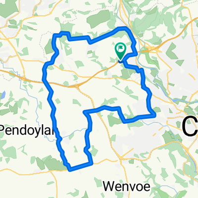
JN32 to Caerphilly Castle and back
A cycling route starting in Radyr, Wales, United Kingdom.
Overview
About this route
- -:--
- Duration
- 18.4 km
- Distance
- 160 m
- Ascent
- 160 m
- Descent
- ---
- Avg. speed
- ---
- Max. altitude

Route quality
Waytypes & surfaces along the route
Waytypes
Cycleway
13.1 km
(71 %)
Quiet road
3.5 km
(19 %)
Surfaces
Paved
17.2 km
(93 %)
Asphalt
16.6 km
(90 %)
Concrete
0.4 km
(2 %)
Continue with Bikemap
Use, edit, or download this cycling route
You would like to ride JN32 to Caerphilly Castle and back or customize it for your own trip? Here is what you can do with this Bikemap route:
Free features
- Save this route as favorite or in collections
- Copy & plan your own version of this route
- Sync your route with Garmin or Wahoo
Premium features
Free trial for 3 days, or one-time payment. More about Bikemap Premium.
- Navigate this route on iOS & Android
- Export a GPX / KML file of this route
- Create your custom printout (try it for free)
- Download this route for offline navigation
Discover more Premium features.
Get Bikemap PremiumFrom our community
Other popular routes starting in Radyr
 Radyr 33k
- Distance
- 33.3 km
- Ascent
- 392 m
- Descent
- 389 m
- Location
- Radyr, Wales, United Kingdom
 BFunctional Circular Bike Ride
- Distance
- 176.6 km
- Ascent
- 1,340 m
- Descent
- 1,341 m
- Location
- Radyr, Wales, United Kingdom
 JN32 to Caerphilly Castle and back
- Distance
- 18.4 km
- Ascent
- 160 m
- Descent
- 160 m
- Location
- Radyr, Wales, United Kingdom
 The Wenvoe Scenic
- Distance
- 45.8 km
- Ascent
- 226 m
- Descent
- 225 m
- Location
- Radyr, Wales, United Kingdom
 Radyr 25k
- Distance
- 33.3 km
- Ascent
- 346 m
- Descent
- 344 m
- Location
- Radyr, Wales, United Kingdom
 Tongwynlais to Talybont via Trefil
- Distance
- 56.3 km
- Ascent
- 846 m
- Descent
- 763 m
- Location
- Radyr, Wales, United Kingdom
 Route in Cardiff
- Distance
- 18.1 km
- Ascent
- 258 m
- Descent
- 126 m
- Location
- Radyr, Wales, United Kingdom
 Radyr 25k
- Distance
- 24.4 km
- Ascent
- 305 m
- Descent
- 306 m
- Location
- Radyr, Wales, United Kingdom
Open it in the app