

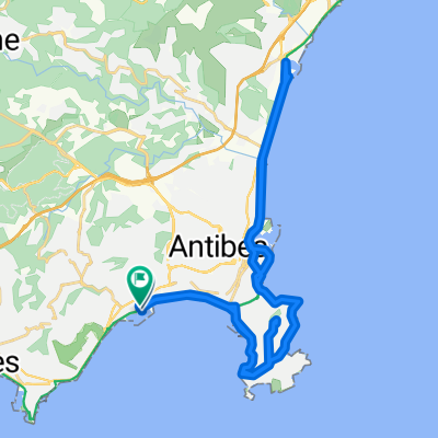
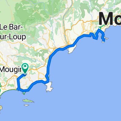
Antibes - Auribeau
A cycling route starting in Vallauris, Provence-Alpes-Côte d'Azur Region, France.
Overview
About this route
This is more of an inpiration than a route I would recommend:
A nice view of Auribeau. However, another route shall be taken to reach the village.
Also, the way back is not optimal as it is easy to get lost; there are many junctions.
- -:--
- Duration
- 43 km
- Distance
- 436 m
- Ascent
- 435 m
- Descent
- ---
- Avg. speed
- ---
- Max. altitude

Route highlights
Points of interest along the route
Point of interest after 16.3 km
Lovely road!
Photo after 21.6 km
Viewpoint of Auribeau
Continue with Bikemap
Use, edit, or download this cycling route
You would like to ride Antibes - Auribeau or customize it for your own trip? Here is what you can do with this Bikemap route:
Free features
- Save this route as favorite or in collections
- Copy & plan your own version of this route
- Sync your route with Garmin or Wahoo
Premium features
Free trial for 3 days, or one-time payment. More about Bikemap Premium.
- Navigate this route on iOS & Android
- Export a GPX / KML file of this route
- Create your custom printout (try it for free)
- Download this route for offline navigation
Discover more Premium features.
Get Bikemap PremiumFrom our community
Other popular routes starting in Vallauris
 Cannes Loop
- Distance
- 38 km
- Ascent
- 341 m
- Descent
- 342 m
- Location
- Vallauris, Provence-Alpes-Côte d'Azur Region, France
 Antibes - Auribeau
- Distance
- 43 km
- Ascent
- 436 m
- Descent
- 435 m
- Location
- Vallauris, Provence-Alpes-Côte d'Azur Region, France
 Mougins Le Haut to Cannes
- Distance
- 15.1 km
- Ascent
- 305 m
- Descent
- 307 m
- Location
- Vallauris, Provence-Alpes-Côte d'Azur Region, France
 Encordoules
- Distance
- 23.4 km
- Ascent
- 381 m
- Descent
- 381 m
- Location
- Vallauris, Provence-Alpes-Côte d'Azur Region, France
 Eze and back
- Distance
- 82.8 km
- Ascent
- 606 m
- Descent
- 605 m
- Location
- Vallauris, Provence-Alpes-Côte d'Azur Region, France
 Brief bike tour from Vallauris to Antibes
- Distance
- 8.7 km
- Ascent
- 151 m
- Descent
- 53 m
- Location
- Vallauris, Provence-Alpes-Côte d'Azur Region, France
 Long ride through Vallauris
- Distance
- 40.2 km
- Ascent
- 101 m
- Descent
- 103 m
- Location
- Vallauris, Provence-Alpes-Côte d'Azur Region, France
 Mougins Le Haut to Saint-Jean Cap-Ferrat
- Distance
- 105.5 km
- Ascent
- 1,009 m
- Descent
- 1,009 m
- Location
- Vallauris, Provence-Alpes-Côte d'Azur Region, France
Open it in the app