

Col de Vars Roundtrip/Okruh kolem Col de Vars
A cycling route starting in Jausiers, Provence-Alpes-Côte d'Azur Region, France.
Overview
About this route
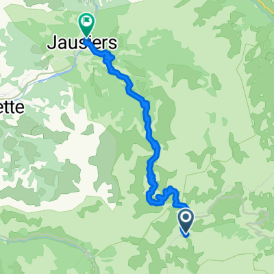
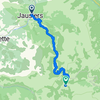
Nice roundtrip over the Col de Vars (2108 m)
Can be run in both directions.
The starting place is a nice picknick site at a small bridge across the river Ubaye. You can take a bath there after the ride. But water is pretty cold.
Alternative places to start are Barcelonette or Jausieres.
- -:--
- Duration
- 124.5 km
- Distance
- 1,663 m
- Ascent
- 1,663 m
- Descent
- ---
- Avg. speed
- ---
- Max. altitude
Continue with Bikemap
Use, edit, or download this cycling route
You would like to ride Col de Vars Roundtrip/Okruh kolem Col de Vars or customize it for your own trip? Here is what you can do with this Bikemap route:
Free features
- Save this route as favorite or in collections
- Copy & plan your own version of this route
- Split it into stages to create a multi-day tour
- Sync your route with Garmin or Wahoo
Premium features
Free trial for 3 days, or one-time payment. More about Bikemap Premium.
- Navigate this route on iOS & Android
- Export a GPX / KML file of this route
- Create your custom printout (try it for free)
- Download this route for offline navigation
Discover more Premium features.
Get Bikemap PremiumFrom our community
Other popular routes starting in Jausiers
 okolo Lac de Serre-Poncon + Bonette
- Distance
- 180.9 km
- Ascent
- 2,172 m
- Descent
- 2,172 m
- Location
- Jausiers, Provence-Alpes-Côte d'Azur Region, France
 Francia Alpok 06 kör
- Distance
- 98.8 km
- Ascent
- 2,659 m
- Descent
- 2,659 m
- Location
- Jausiers, Provence-Alpes-Côte d'Azur Region, France
 1-VILLE-VIEILLE
- Distance
- 109.3 km
- Ascent
- 3,678 m
- Descent
- 3,514 m
- Location
- Jausiers, Provence-Alpes-Côte d'Azur Region, France
 Col de la cime della Bonette m.2802 - Jausieres
- Distance
- 23.6 km
- Ascent
- 10 m
- Descent
- 1,576 m
- Location
- Jausiers, Provence-Alpes-Côte d'Azur Region, France
 Jausieres - Col de la Bonette
- Distance
- 23.7 km
- Ascent
- 1,599 m
- Descent
- 27 m
- Location
- Jausiers, Provence-Alpes-Côte d'Azur Region, France
 Tunnel du Parpaillon
- Distance
- 49.4 km
- Ascent
- 1,508 m
- Descent
- 1,811 m
- Location
- Jausiers, Provence-Alpes-Côte d'Azur Region, France
 etapa Jausiers 2
- Distance
- 44.4 km
- Ascent
- 927 m
- Descent
- 934 m
- Location
- Jausiers, Provence-Alpes-Côte d'Azur Region, France
 8. Etappe Oberdiessbach Le Lavandou Teil 2
- Distance
- 11.4 km
- Ascent
- 775 m
- Descent
- 650 m
- Location
- Jausiers, Provence-Alpes-Côte d'Azur Region, France
Open it in the app