
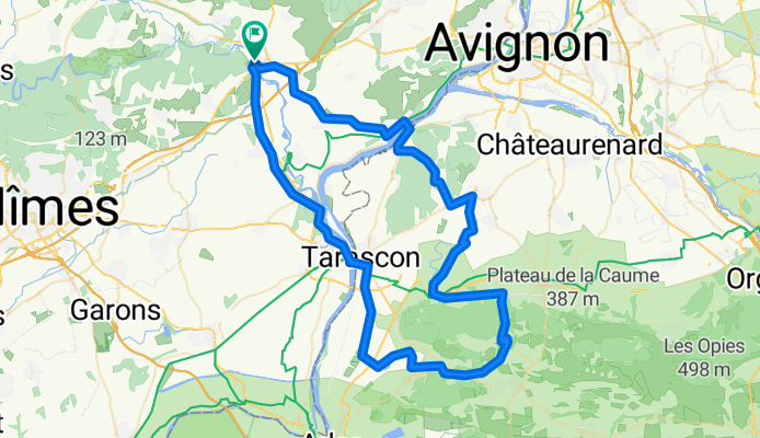
Les Baux-de-Provence
A cycling route starting in Remoulins, Occitanie, France.
Overview
About this route
- -:--
- Duration
- 91.5 km
- Distance
- 399 m
- Ascent
- 397 m
- Descent
- ---
- Avg. speed
- ---
- Max. altitude
Route quality
Waytypes & surfaces along the route
Waytypes
Road
44.8 km
(49 %)
Quiet road
16.5 km
(18 %)
Surfaces
Paved
56.7 km
(62 %)
Asphalt
56.7 km
(62 %)
Undefined
34.8 km
(38 %)
Continue with Bikemap
Use, edit, or download this cycling route
You would like to ride Les Baux-de-Provence or customize it for your own trip? Here is what you can do with this Bikemap route:
Free features
- Save this route as favorite or in collections
- Copy & plan your own version of this route
- Split it into stages to create a multi-day tour
- Sync your route with Garmin or Wahoo
Premium features
Free trial for 3 days, or one-time payment. More about Bikemap Premium.
- Navigate this route on iOS & Android
- Export a GPX / KML file of this route
- Create your custom printout (try it for free)
- Download this route for offline navigation
Discover more Premium features.
Get Bikemap PremiumFrom our community
Other popular routes starting in Remoulins
 Remoulins-Sète132KM240u6h45via Nîmes- Montpellier
- Distance
- 132.1 km
- Ascent
- 256 m
- Descent
- 183 m
- Location
- Remoulins, Occitanie, France
 Fournès - Circle to Écluse de Vallabrègues
- Distance
- 49.8 km
- Ascent
- 211 m
- Descent
- 210 m
- Location
- Remoulins, Occitanie, France
 Route 2 Remoulins - Les Beaux
- Distance
- 91.5 km
- Ascent
- 444 m
- Descent
- 444 m
- Location
- Remoulins, Occitanie, France
 remoulins 64
- Distance
- 64.1 km
- Ascent
- 513 m
- Descent
- 506 m
- Location
- Remoulins, Occitanie, France
 Route 6 Remoulins Chateauneuf
- Distance
- 80.9 km
- Ascent
- 489 m
- Descent
- 489 m
- Location
- Remoulins, Occitanie, France
 route 5 remoulins bagnols sur ceze
- Distance
- 84 km
- Ascent
- 604 m
- Descent
- 607 m
- Location
- Remoulins, Occitanie, France
 Les Baux-de-Provence
- Distance
- 91.5 km
- Ascent
- 399 m
- Descent
- 397 m
- Location
- Remoulins, Occitanie, France
 Pont du Gard
- Distance
- 15.2 km
- Ascent
- 120 m
- Descent
- 120 m
- Location
- Remoulins, Occitanie, France
Open it in the app