

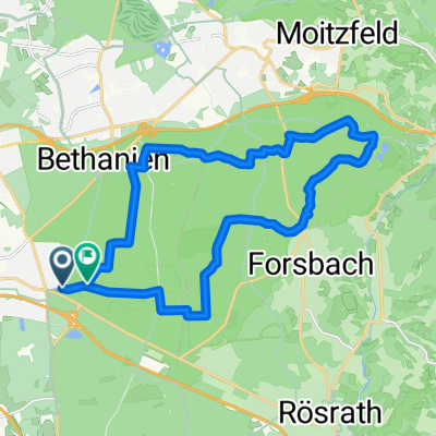
Zeitfahren um den Flughafen
A cycling route starting in Rath, North Rhine-Westphalia, Germany.
Overview
About this route
Über Rath und Wahn nach Altenrath und zurück.
- -:--
- Duration
- 42.2 km
- Distance
- 139 m
- Ascent
- 139 m
- Descent
- ---
- Avg. speed
- ---
- Max. altitude
Route quality
Waytypes & surfaces along the route
Waytypes
Busy road
20.2 km
(48 %)
Path
11.2 km
(27 %)
Surfaces
Paved
38.7 km
(92 %)
Unpaved
0.1 km
(<1 %)
Asphalt
35.2 km
(83 %)
Paving stones
2 km
(5 %)
Continue with Bikemap
Use, edit, or download this cycling route
You would like to ride Zeitfahren um den Flughafen or customize it for your own trip? Here is what you can do with this Bikemap route:
Free features
- Save this route as favorite or in collections
- Copy & plan your own version of this route
- Sync your route with Garmin or Wahoo
Premium features
Free trial for 3 days, or one-time payment. More about Bikemap Premium.
- Navigate this route on iOS & Android
- Export a GPX / KML file of this route
- Create your custom printout (try it for free)
- Download this route for offline navigation
Discover more Premium features.
Get Bikemap PremiumFrom our community
Other popular routes starting in Rath
 Königsforst (W)
- Distance
- 10.7 km
- Ascent
- 112 m
- Descent
- 112 m
- Location
- Rath, North Rhine-Westphalia, Germany
 Zeitfahren um den Flughafen
- Distance
- 42.2 km
- Ascent
- 139 m
- Descent
- 139 m
- Location
- Rath, North Rhine-Westphalia, Germany
 rösrath
- Distance
- 17 km
- Ascent
- 93 m
- Descent
- 101 m
- Location
- Rath, North Rhine-Westphalia, Germany
 Königsforst kurz und knackig
- Distance
- 27.4 km
- Ascent
- 506 m
- Descent
- 511 m
- Location
- Rath, North Rhine-Westphalia, Germany
 Königsforst First Try
- Distance
- 30.2 km
- Ascent
- 473 m
- Descent
- 474 m
- Location
- Rath, North Rhine-Westphalia, Germany
 Cross Königsforst
- Distance
- 20 km
- Ascent
- 201 m
- Descent
- 194 m
- Location
- Rath, North Rhine-Westphalia, Germany
 Wahner Heide, Sülz, Agger, Sieg und Rhein
- Distance
- 49.8 km
- Ascent
- 142 m
- Descent
- 149 m
- Location
- Rath, North Rhine-Westphalia, Germany
 Königsforst - Bergisches - Agger - Wahner Heide
- Distance
- 48.5 km
- Ascent
- 443 m
- Descent
- 445 m
- Location
- Rath, North Rhine-Westphalia, Germany
Open it in the app