
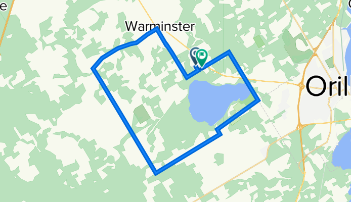
Bass Lake Route
A cycling route starting in Orillia, Ontario, Canada.
Overview
About this route
horseshoe valley road; 13th line; Warmnster Sideroad; 10th line; Bass Lake Sideroad; 15th line; Wainman line; Division Road; Edith Street; home
- -:--
- Duration
- 27.8 km
- Distance
- 219 m
- Ascent
- 216 m
- Descent
- ---
- Avg. speed
- ---
- Avg. speed
Route quality
Waytypes & surfaces along the route
Waytypes
Quiet road
19.1 km
(69 %)
Road
8.7 km
(31 %)
Surfaces
Paved
4.7 km
(17 %)
Unpaved
9.4 km
(34 %)
Unpaved (undefined)
9.4 km
(34 %)
Asphalt
4.7 km
(17 %)
Undefined
13.8 km
(50 %)
Continue with Bikemap
Use, edit, or download this cycling route
You would like to ride Bass Lake Route or customize it for your own trip? Here is what you can do with this Bikemap route:
Free features
- Save this route as favorite or in collections
- Copy & plan your own version of this route
- Sync your route with Garmin or Wahoo
Premium features
Free trial for 3 days, or one-time payment. More about Bikemap Premium.
- Navigate this route on iOS & Android
- Export a GPX / KML file of this route
- Create your custom printout (try it for free)
- Download this route for offline navigation
Discover more Premium features.
Get Bikemap PremiumFrom our community
Other popular routes starting in Orillia
 63 Fowlie St, Orillia to 67 Fowlie St, Orillia
- Distance
- 21.1 km
- Ascent
- 210 m
- Descent
- 215 m
- Location
- Orillia, Ontario, Canada
 Home to Tina's
- Distance
- 187.9 km
- Ascent
- 603 m
- Descent
- 506 m
- Location
- Orillia, Ontario, Canada
 014 - Orillia - Huntsville
- Distance
- 116.5 km
- Ascent
- 991 m
- Descent
- 919 m
- Location
- Orillia, Ontario, Canada
 Wasaga - Port McNicoll
- Distance
- 152.8 km
- Ascent
- 585 m
- Descent
- 585 m
- Location
- Orillia, Ontario, Canada
 Orillia - 33k
- Distance
- 33 km
- Ascent
- 182 m
- Descent
- 182 m
- Location
- Orillia, Ontario, Canada
 Braestone Climb 2
- Distance
- 18.8 km
- Ascent
- 166 m
- Descent
- 181 m
- Location
- Orillia, Ontario, Canada
 435 Jamieson Dr, Orillia to 435 Jamieson Dr, Orillia
- Distance
- 15.8 km
- Ascent
- 178 m
- Descent
- 180 m
- Location
- Orillia, Ontario, Canada
 Simcoe county loop
- Distance
- 159.8 km
- Ascent
- 1,050 m
- Descent
- 1,050 m
- Location
- Orillia, Ontario, Canada
Open it in the app