
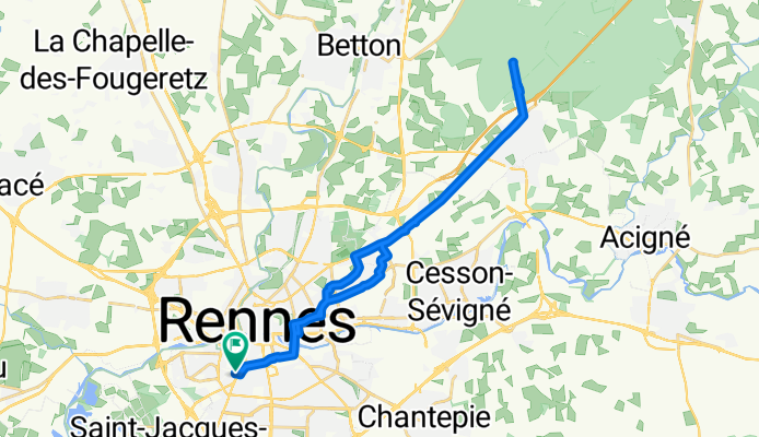
Closest Mégalithe
A cycling route starting in Rennes, Brittany Region, France.
Overview
About this route
Ride to the "Mégalithes du Carrefour de la Grande Lune"
- -:--
- Duration
- 27.5 km
- Distance
- 123 m
- Ascent
- 123 m
- Descent
- ---
- Avg. speed
- ---
- Max. altitude

Route quality
Waytypes & surfaces along the route
Waytypes
Cycleway
12.1 km
(44 %)
Quiet road
3.9 km
(14 %)
Surfaces
Paved
25.6 km
(93 %)
Asphalt
25.6 km
(93 %)
Undefined
1.9 km
(7 %)
Continue with Bikemap
Use, edit, or download this cycling route
You would like to ride Closest Mégalithe or customize it for your own trip? Here is what you can do with this Bikemap route:
Free features
- Save this route as favorite or in collections
- Copy & plan your own version of this route
- Sync your route with Garmin or Wahoo
Premium features
Free trial for 3 days, or one-time payment. More about Bikemap Premium.
- Navigate this route on iOS & Android
- Export a GPX / KML file of this route
- Create your custom printout (try it for free)
- Download this route for offline navigation
Discover more Premium features.
Get Bikemap PremiumFrom our community
Other popular routes starting in Rennes
 Bretagne Nord - Est (partie 1)
- Distance
- 149.6 km
- Ascent
- 220 m
- Descent
- 234 m
- Location
- Rennes, Brittany Region, France
 Itinéraire facile en Rennes
- Distance
- 12.3 km
- Ascent
- 291 m
- Descent
- 290 m
- Location
- Rennes, Brittany Region, France
 Rennes - Betton - Canal - Tinténiac
- Distance
- 45.2 km
- Ascent
- 100 m
- Descent
- 113 m
- Location
- Rennes, Brittany Region, France
 Bretagne Nord - Est (2014)
- Distance
- 278.5 km
- Ascent
- 604 m
- Descent
- 535 m
- Location
- Rennes, Brittany Region, France
 Le Moulin Desgués
- Distance
- 12.9 km
- Ascent
- 75 m
- Descent
- 72 m
- Location
- Rennes, Brittany Region, France
 Rennes Chartres Pont Réan Bourg Guichen pt Réan Bruz St Jacques
- Distance
- 57.2 km
- Ascent
- 350 m
- Descent
- 350 m
- Location
- Rennes, Brittany Region, France
 Ida para floresta de Rennes
- Distance
- 33.5 km
- Ascent
- 193 m
- Descent
- 193 m
- Location
- Rennes, Brittany Region, France
 Tour de France 2015 - Stage 8
- Distance
- 190.6 km
- Ascent
- 1,011 m
- Descent
- 751 m
- Location
- Rennes, Brittany Region, France
Open it in the app