

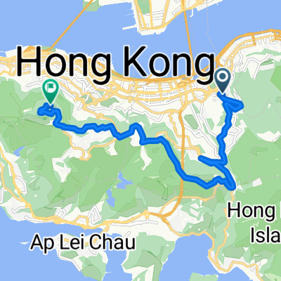
Bowen Drive to Wong Chuk Hang MTR
A cycling route starting in Wan Chai, Wan Chai, Hong Kong.
Overview
About this route
- -:--
- Duration
- 12 km
- Distance
- 287 m
- Ascent
- 400 m
- Descent
- ---
- Avg. speed
- ---
- Max. altitude
Continue with Bikemap
Use, edit, or download this cycling route
You would like to ride Bowen Drive to Wong Chuk Hang MTR or customize it for your own trip? Here is what you can do with this Bikemap route:
Free features
- Save this route as favorite or in collections
- Copy & plan your own version of this route
- Sync your route with Garmin or Wahoo
Premium features
Free trial for 3 days, or one-time payment. More about Bikemap Premium.
- Navigate this route on iOS & Android
- Export a GPX / KML file of this route
- Create your custom printout (try it for free)
- Download this route for offline navigation
Discover more Premium features.
Get Bikemap PremiumFrom our community
Other popular routes starting in Wan Chai
 2 Pak Fuk Road, Quarry Bay to 1–3 Healthy Street West, North Point
- Distance
- 19.3 km
- Ascent
- 14 m
- Descent
- 46 m
- Location
- Wan Chai, Wan Chai, Hong Kong
 Bowen Drive to Wong Chuk Hang MTR
- Distance
- 12 km
- Ascent
- 287 m
- Descent
- 400 m
- Location
- Wan Chai, Wan Chai, Hong Kong
 香港環島
香港環島- Distance
- 30.1 km
- Ascent
- 717 m
- Descent
- 707 m
- Location
- Wan Chai, Wan Chai, Hong Kong
 Chai Wan -> Chai Wan ( Around Hong Kong Island )
- Distance
- 64.3 km
- Ascent
- 776 m
- Descent
- 776 m
- Location
- Wan Chai, Wan Chai, Hong Kong
 Island Eastern Corridor, Sai Wan Ho to 26 Tai On Street, Sai Wan Ho
- Distance
- 10.9 km
- Ascent
- 281 m
- Descent
- 245 m
- Location
- Wan Chai, Wan Chai, Hong Kong
 北角_鶴咀_石澳
- Distance
- 39.4 km
- Ascent
- 728 m
- Descent
- 728 m
- Location
- Wan Chai, Wan Chai, Hong Kong
 大坑道去山頂
- Distance
- 12.9 km
- Ascent
- 827 m
- Descent
- 324 m
- Location
- Wan Chai, Wan Chai, Hong Kong
 the peak
- Distance
- 10.4 km
- Ascent
- 728 m
- Descent
- 369 m
- Location
- Wan Chai, Wan Chai, Hong Kong
Open it in the app