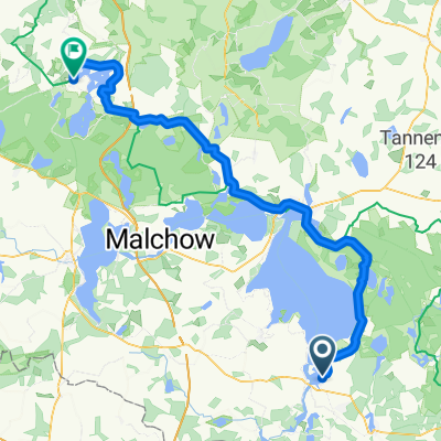
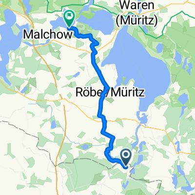
Boek-Jabel
A cycling route starting in Rechlin, Mecklenburg-Vorpommern, Germany.
Overview
About this route
- -:--
- Duration
- 36.8 km
- Distance
- 137 m
- Ascent
- 131 m
- Descent
- ---
- Avg. speed
- ---
- Max. altitude
Route quality
Waytypes & surfaces along the route
Waytypes
Path
12.1 km
(33 %)
Quiet road
10.7 km
(29 %)
Surfaces
Paved
21 km
(57 %)
Unpaved
12.5 km
(34 %)
Asphalt
21 km
(57 %)
Loose gravel
8.8 km
(24 %)
Continue with Bikemap
Use, edit, or download this cycling route
You would like to ride Boek-Jabel or customize it for your own trip? Here is what you can do with this Bikemap route:
Free features
- Save this route as favorite or in collections
- Copy & plan your own version of this route
- Sync your route with Garmin or Wahoo
Premium features
Free trial for 3 days, or one-time payment. More about Bikemap Premium.
- Navigate this route on iOS & Android
- Export a GPX / KML file of this route
- Create your custom printout (try it for free)
- Download this route for offline navigation
Discover more Premium features.
Get Bikemap PremiumFrom our community
Other popular routes starting in Rechlin
Mittelstraße, Rechlin nach Imkerweg, Rechlin- Distance
- 64.9 km
- Ascent
- 259 m
- Descent
- 259 m
- Location
- Rechlin, Mecklenburg-Vorpommern, Germany
Rechlin - Schönermark- Distance
- 68.7 km
- Ascent
- 379 m
- Descent
- 391 m
- Location
- Rechlin, Mecklenburg-Vorpommern, Germany
Steyer: Mirower Runde- Distance
- 64.5 km
- Ascent
- 192 m
- Descent
- 191 m
- Location
- Rechlin, Mecklenburg-Vorpommern, Germany
Imkerweg, Rechlin nach Mittelstraße, Rechlin- Distance
- 19.6 km
- Ascent
- 28 m
- Descent
- 28 m
- Location
- Rechlin, Mecklenburg-Vorpommern, Germany
Sandberg 1, Wittstock/Dosse nach Bliesendorfer Dorfstraße 23, Werder (Havel)- Distance
- 148.9 km
- Ascent
- 783 m
- Descent
- 792 m
- Location
- Rechlin, Mecklenburg-Vorpommern, Germany
Fritz-Reuter-Straße, Rechlin nach Markt, Krakow am See- Distance
- 78.2 km
- Ascent
- 519 m
- Descent
- 534 m
- Location
- Rechlin, Mecklenburg-Vorpommern, Germany
Rechlin - Malchow- Distance
- 40.3 km
- Ascent
- 145 m
- Descent
- 137 m
- Location
- Rechlin, Mecklenburg-Vorpommern, Germany
DE-Rechlin-57 km- Distance
- 56.9 km
- Ascent
- 147 m
- Descent
- 147 m
- Location
- Rechlin, Mecklenburg-Vorpommern, Germany
Open it in the app

