

Overview
About this route
- -:--
- Duration
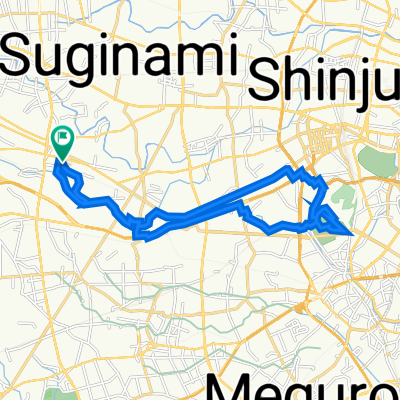
- 9.3 km
- Distance
- 33 m
- Ascent
- 39 m
- Descent
- ---
- Avg. speed
- ---
- Max. altitude

Part of
Tokyo
4 stages
Route quality
Waytypes & surfaces along the route
Waytypes
Quiet road
5.9 km
(63 %)
Pedestrian area
1.8 km
(20 %)
Surfaces
Paved
1.5 km
(16 %)
Paved (undefined)
0.7 km
(8 %)
Asphalt
0.7 km
(7 %)
Continue with Bikemap
Use, edit, or download this cycling route
You would like to ride Setagaya part 3 or customize it for your own trip? Here is what you can do with this Bikemap route:
Free features
- Save this route as favorite or in collections
- Copy & plan your own version of this route
- Sync your route with Garmin or Wahoo
Premium features
Free trial for 3 days, or one-time payment. More about Bikemap Premium.
- Navigate this route on iOS & Android
- Export a GPX / KML file of this route
- Create your custom printout (try it for free)
- Download this route for offline navigation
Discover more Premium features.
Get Bikemap PremiumFrom our community
Other popular routes starting in Mitaka-shi
 cycling around tama cemetery
- Distance
- 12.9 km
- Ascent
- 416 m
- Descent
- 421 m
- Location
- Mitaka-shi, Tokyo, Japan
 Setagaya part 3
- Distance
- 9.3 km
- Ascent
- 33 m
- Descent
- 39 m
- Location
- Mitaka-shi, Tokyo, Japan
 June 2, 2020
- Distance
- 59.1 km
- Ascent
- 612 m
- Descent
- 611 m
- Location
- Mitaka-shi, Tokyo, Japan
 Tama River - Tama Lake
- Distance
- 44.8 km
- Ascent
- 332 m
- Descent
- 325 m
- Location
- Mitaka-shi, Tokyo, Japan
 高井戸東3丁目20-28, 杉並区 to 高井戸東3丁目20-28, 杉並区
- Distance
- 21.8 km
- Ascent
- 99 m
- Descent
- 102 m
- Location
- Mitaka-shi, Tokyo, Japan
 高井戸東3丁目20-28, 杉並区 to 高井戸東3丁目20-28, 杉並区
- Distance
- 11 km
- Ascent
- 63 m
- Descent
- 62 m
- Location
- Mitaka-shi, Tokyo, Japan
 高井戸東3丁目20-28, 杉並区 to 高井戸西1丁目12-16, 杉並区
- Distance
- 1.8 km
- Ascent
- 10 m
- Descent
- 10 m
- Location
- Mitaka-shi, Tokyo, Japan
 高井戸東3丁目20-28, 杉並区 to 高井戸東3丁目20-28, 杉並区
- Distance
- 28.9 km
- Ascent
- 80 m
- Descent
- 79 m
- Location
- Mitaka-shi, Tokyo, Japan
Open it in the app