Jura Gebirgsweg - Gelbkreuz
A cycling route starting in Vorra, Bavaria, Germany.
Overview
About this route
<p><strong>Trail No. 040: Yellow Cross „Jura Mountain Path“</strong> <strong>Destination Trail Vorra (District of Nürnberger Land) – Schloßberg (Market of Schnaittach)</strong> </p>
<p> </p>
<p> </p>
<p>Vorra – 3.9 – Hirschbach – 3.5 – Bürtel-Ost – 1.1 – Heuchling – 1.8 – Appelsberg – 1.2 – Pommelsbrunn, Kirchplatz – 2.1 – Arzlohe – 0.4 – Kapellenruine – 1.4 – Förrenbach – 1.3 – Reicheneck – 0.8 – Kainsbach – 2.3 – Deckersberg – 1.1 – Deckersberg, Edelweißhütte – 3.9 – Engelthal – 3.8 – Henfenfeld, train station – 2.6 – Reichenschwand, train station – 3.0 – Großer Hansgörgel – 3.9 – Moosbrunner Berg – 4.9 – Schloßberg</p>
<p> </p>
<p>Source: Fränkischer Albverein</p>
Translated, show original (German)- -:--
- Duration
- 42.8 km
- Distance
- 1,100 m
- Ascent
- 958 m
- Descent
- ---
- Avg. speed
- ---
- Max. altitude
Continue with Bikemap
Use, edit, or download this cycling route
You would like to ride Jura Gebirgsweg - Gelbkreuz or customize it for your own trip? Here is what you can do with this Bikemap route:
Free features
- Save this route as favorite or in collections
- Copy & plan your own version of this route
- Sync your route with Garmin or Wahoo
Premium features
Free trial for 3 days, or one-time payment. More about Bikemap Premium.
- Navigate this route on iOS & Android
- Export a GPX / KML file of this route
- Create your custom printout (try it for free)
- Download this route for offline navigation
Discover more Premium features.
Get Bikemap PremiumFrom our community
Other popular routes starting in Vorra
- Jura Gebirgsweg - Gelbkreuz
- Distance
- 42.8 km
- Ascent
- 1,100 m
- Descent
- 958 m
- Location
- Vorra, Bavaria, Germany
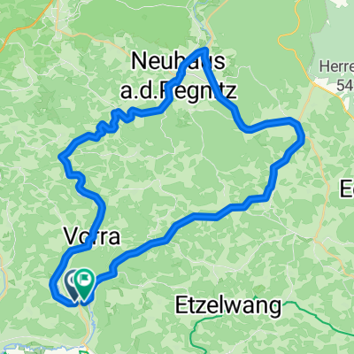
- Eschenbach-Etzelwang
- Distance
- 39.4 km
- Ascent
- 211 m
- Descent
- 210 m
- Location
- Vorra, Bavaria, Germany
- 2012 Pegnitzradweg-RotMain Radweg-Bayreuth
- Distance
- 78.4 km
- Ascent
- 438 m
- Descent
- 494 m
- Location
- Vorra, Bavaria, Germany
- Vorra_Pielenhofen
- Distance
- 85.1 km
- Ascent
- 393 m
- Descent
- 418 m
- Location
- Vorra, Bavaria, Germany
- Bahnhofstraße 12, Vorra nach Bahnhofstraße 4a, Vorra
- Distance
- 14 km
- Ascent
- 55 m
- Descent
- 53 m
- Location
- Vorra, Bavaria, Germany
- Hirschbachtal
- Distance
- 19 km
- Ascent
- 458 m
- Descent
- 463 m
- Location
- Vorra, Bavaria, Germany
- Eschenbak - Flachslanden
- Distance
- 81.8 km
- Ascent
- 306 m
- Descent
- 186 m
- Location
- Vorra, Bavaria, Germany
- Vorra nach Lauf
- Distance
- 25.5 km
- Ascent
- 72 m
- Descent
- 102 m
- Location
- Vorra, Bavaria, Germany
Open it in the app