

Peter Schöner Weg - Rotpunkt
A cycling route starting in Weigendorf, Bavaria, Germany.
Overview
About this route
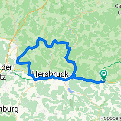
Route No. 087: Red dot „Peter-Schöner-Weg“ Circular path Hartmannshof (municipality of Pommelsbrunn, district of Nürnberger Land) – Pommelsbrunn
Source: Franconian Alpine Association
Peter Schöner, died in 1959, section leader of the mountain rescue.
Hartmannshof, Station – 1,9 – Oed – 2,1 – Lehendorf – 1,4 – Etzelwang-West – 3,1 – Schmidtstadt, main street – 3,0 – Prellstein – 2,4 – Bürtel-East – 1,1 – Heuchling – 3,7 – Pommelsbrunn – 0,4 – Weidenmühle – 1,1 – Reckenberg – 1,8 – Hohler Fels – 2,8 – Arzlohe – 0,3 – Chapel ruins – 1,2 – Cathedral – 1,0 – Hochberg – 0,5 – Mittelburg-North – 3,0 – Hartmannshof, Station.
- -:--
- Duration
- 30.7 km
- Distance
- 684 m
- Ascent
- 686 m
- Descent
- ---
- Avg. speed
- ---
- Max. altitude
Route quality
Waytypes & surfaces along the route
Waytypes
Track
18.4 km
(60 %)
Path
8 km
(26 %)
Surfaces
Paved
4.3 km
(14 %)
Unpaved
21.2 km
(69 %)
Ground
11.7 km
(38 %)
Unpaved (undefined)
5.2 km
(17 %)
Continue with Bikemap
Use, edit, or download this cycling route
You would like to ride Peter Schöner Weg - Rotpunkt or customize it for your own trip? Here is what you can do with this Bikemap route:
Free features
- Save this route as favorite or in collections
- Copy & plan your own version of this route
- Sync your route with Garmin or Wahoo
Premium features
Free trial for 3 days, or one-time payment. More about Bikemap Premium.
- Navigate this route on iOS & Android
- Export a GPX / KML file of this route
- Create your custom printout (try it for free)
- Download this route for offline navigation
Discover more Premium features.
Get Bikemap PremiumFrom our community
Other popular routes starting in Weigendorf
 5 Flüsse Radweg Teil 2
- Distance
- 47.9 km
- Ascent
- 96 m
- Descent
- 211 m
- Location
- Weigendorf, Bavaria, Germany
 Simultankirchen-Radweg Route 1 ab Hartmannshof und zurück
- Distance
- 27.3 km
- Ascent
- 387 m
- Descent
- 387 m
- Location
- Weigendorf, Bavaria, Germany
 Lichtenegg 1, Birgland nach Lichtenegg 1, Birgland
- Distance
- 8 km
- Ascent
- 246 m
- Descent
- 242 m
- Location
- Weigendorf, Bavaria, Germany
 Hartmannshof-Happurg-Lichtenegg-Lehenhammer
- Distance
- 43.5 km
- Ascent
- 958 m
- Descent
- 957 m
- Location
- Weigendorf, Bavaria, Germany
 wolfstein
- Distance
- 32.7 km
- Ascent
- 357 m
- Descent
- 298 m
- Location
- Weigendorf, Bavaria, Germany
 Wei_Kersbach_Morsbrunn_Düsselbach
- Distance
- 51.3 km
- Ascent
- 545 m
- Descent
- 564 m
- Location
- Weigendorf, Bavaria, Germany
 Peter Schöner Weg - Rotpunkt
- Distance
- 30.7 km
- Ascent
- 684 m
- Descent
- 686 m
- Location
- Weigendorf, Bavaria, Germany
 Haunritz_Lichtenegg_Kronberg_Högen
- Distance
- 16.4 km
- Ascent
- 493 m
- Descent
- 487 m
- Location
- Weigendorf, Bavaria, Germany
Open it in the app