

SG-Solingener Klingenpfad -Light-
A cycling route starting in Leichlingen, North Rhine-Westphalia, Germany.
Overview
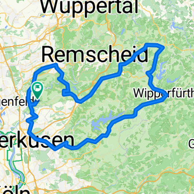
About this route
Here is the Light variant of the Solingen Blade Path, for all with
- HM allergy
- uphill aversion
- ascent phobia
49km 850HM approximately 3.5h pure riding time
- -:--
- Duration
- 48.8 km
- Distance
- 453 m
- Ascent
- 452 m
- Descent
- ---
- Avg. speed
- ---
- Max. altitude
Route quality
Waytypes & surfaces along the route
Waytypes
Track
20.5 km
(42 %)
Quiet road
10.2 km
(21 %)
Surfaces
Paved
17.1 km
(35 %)
Unpaved
25.9 km
(53 %)
Asphalt
15.6 km
(32 %)
Ground
9.3 km
(19 %)
Continue with Bikemap
Use, edit, or download this cycling route
You would like to ride SG-Solingener Klingenpfad -Light- or customize it for your own trip? Here is what you can do with this Bikemap route:
Free features
- Save this route as favorite or in collections
- Copy & plan your own version of this route
- Sync your route with Garmin or Wahoo
Premium features
Free trial for 3 days, or one-time payment. More about Bikemap Premium.
- Navigate this route on iOS & Android
- Export a GPX / KML file of this route
- Create your custom printout (try it for free)
- Download this route for offline navigation
Discover more Premium features.
Get Bikemap PremiumFrom our community
Other popular routes starting in Leichlingen
 26. August 09:15 Lennep
- Distance
- 63.4 km
- Ascent
- 460 m
- Descent
- 462 m
- Location
- Leichlingen, North Rhine-Westphalia, Germany
 Rheintour
- Distance
- 31 km
- Ascent
- 119 m
- Descent
- 121 m
- Location
- Leichlingen, North Rhine-Westphalia, Germany
 Richtig geile MTB Tour!!!
- Distance
- 49.6 km
- Ascent
- 606 m
- Descent
- 609 m
- Location
- Leichlingen, North Rhine-Westphalia, Germany
 2009.03.22 -Solingen
- Distance
- 35 km
- Ascent
- 653 m
- Descent
- 653 m
- Location
- Leichlingen, North Rhine-Westphalia, Germany
 Bergische Trainings Runde
- Distance
- 106.4 km
- Ascent
- 959 m
- Descent
- 1,015 m
- Location
- Leichlingen, North Rhine-Westphalia, Germany
 SG-Solingener Klingenpfad -Light-
- Distance
- 48.8 km
- Ascent
- 453 m
- Descent
- 452 m
- Location
- Leichlingen, North Rhine-Westphalia, Germany
 Von Leverkusen bis Solingen
- Distance
- 7.8 km
- Ascent
- 151 m
- Descent
- 94 m
- Location
- Leichlingen, North Rhine-Westphalia, Germany
 SG-Solingener Klingenpfad -Light- CLONED FROM ROUTE 489684
- Distance
- 48.8 km
- Ascent
- 453 m
- Descent
- 452 m
- Location
- Leichlingen, North Rhine-Westphalia, Germany
Open it in the app