
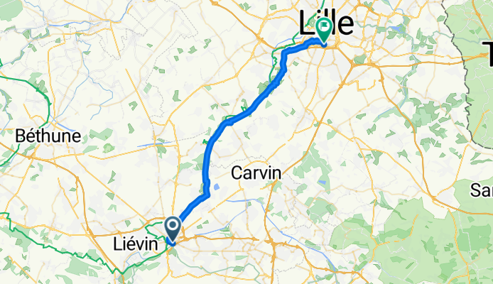
Fanny Nathan
A cycling route starting in Lens, Hauts-de-France, France.
Overview
About this route
- -:--
- Duration
- 32.8 km
- Distance
- 52 m
- Ascent
- 63 m
- Descent
- ---
- Avg. speed
- ---
- Max. altitude

Continue with Bikemap
Use, edit, or download this cycling route
You would like to ride Fanny Nathan or customize it for your own trip? Here is what you can do with this Bikemap route:
Free features
- Save this route as favorite or in collections
- Copy & plan your own version of this route
- Sync your route with Garmin or Wahoo
Premium features
Free trial for 3 days, or one-time payment. More about Bikemap Premium.
- Navigate this route on iOS & Android
- Export a GPX / KML file of this route
- Create your custom printout (try it for free)
- Download this route for offline navigation
Discover more Premium features.
Get Bikemap PremiumFrom our community
Other popular routes starting in Lens
 etape 9 tdf 2018
- Distance
- 193.5 km
- Ascent
- 778 m
- Descent
- 762 m
- Location
- Lens, Hauts-de-France, France
 Lens- Vimy - Louvre
- Distance
- 20.1 km
- Ascent
- 155 m
- Descent
- 155 m
- Location
- Lens, Hauts-de-France, France
 17bis Place Jean Jaurès, Lens à Place des Héros, Arras
- Distance
- 22.4 km
- Ascent
- 206 m
- Descent
- 170 m
- Location
- Lens, Hauts-de-France, France
 De 20 Boulevard Émile Basly, Lens à Boulevard de la Plaine, Grenay
- Distance
- 8.4 km
- Ascent
- 73 m
- Descent
- 49 m
- Location
- Lens, Hauts-de-France, France
 Jour 1 - Marchiennes
- Distance
- 41.9 km
- Ascent
- 83 m
- Descent
- 101 m
- Location
- Lens, Hauts-de-France, France
 Domicile/Lens : 73 km
- Distance
- 73 km
- Ascent
- 60 m
- Descent
- 61 m
- Location
- Lens, Hauts-de-France, France
 Lens à Place Léon Debouverie, Amiens
- Distance
- 105.6 km
- Ascent
- 580 m
- Descent
- 580 m
- Location
- Lens, Hauts-de-France, France
 Lens - Terrils
- Distance
- 8.9 km
- Ascent
- 58 m
- Descent
- 59 m
- Location
- Lens, Hauts-de-France, France
Open it in the app