

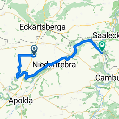
Feierabendrunde
A cycling route starting in Rannstedt, Free State of Thuringia, Germany.
Overview
About this route
<br />Zum Start geht´s schön Bergab, dann etwas hügelig aber mäßig den größten Teil weiter und zum Schluss Bergauf. Bei normalem Tempo in ca. 1h 15min (ganz nach Tegesform).
- -:--
- Duration
- 17.5 km
- Distance
- 136 m
- Ascent
- 135 m
- Descent
- ---
- Avg. speed
- ---
- Max. altitude
Route quality
Waytypes & surfaces along the route
Waytypes
Quiet road
6.3 km
(36 %)
Track
3.8 km
(22 %)
Surfaces
Paved
12.1 km
(69 %)
Unpaved
3.6 km
(21 %)
Asphalt
11 km
(63 %)
Ground
2.4 km
(14 %)
Continue with Bikemap
Use, edit, or download this cycling route
You would like to ride Feierabendrunde or customize it for your own trip? Here is what you can do with this Bikemap route:
Free features
- Save this route as favorite or in collections
- Copy & plan your own version of this route
- Sync your route with Garmin or Wahoo
Premium features
Free trial for 3 days, or one-time payment. More about Bikemap Premium.
- Navigate this route on iOS & Android
- Export a GPX / KML file of this route
- Create your custom printout (try it for free)
- Download this route for offline navigation
Discover more Premium features.
Get Bikemap PremiumFrom our community
Other popular routes starting in Rannstedt
 eckartsbergaer berg
- Distance
- 5.3 km
- Ascent
- 126 m
- Descent
- 49 m
- Location
- Rannstedt, Free State of Thuringia, Germany
 eckartsbergaer berg
- Distance
- 5.5 km
- Ascent
- 129 m
- Descent
- 54 m
- Location
- Rannstedt, Free State of Thuringia, Germany
 ICE-Tunnelbaustelle an der Finne
- Distance
- 24.3 km
- Ascent
- 142 m
- Descent
- 145 m
- Location
- Rannstedt, Free State of Thuringia, Germany
 Feierabendrunde
- Distance
- 17.5 km
- Ascent
- 136 m
- Descent
- 135 m
- Location
- Rannstedt, Free State of Thuringia, Germany
 Dorfstraße 69, Rannstedt nach L1061, Großheringen
- Distance
- 26.5 km
- Ascent
- 179 m
- Descent
- 258 m
- Location
- Rannstedt, Free State of Thuringia, Germany
 Dorfstraße 50A, Rannstedt nach Großheringen
- Distance
- 23 km
- Ascent
- 104 m
- Descent
- 167 m
- Location
- Rannstedt, Free State of Thuringia, Germany
 Dorfstraße 69, Rannstedt nach Dorfstraße 24, Rannstedt
- Distance
- 33.1 km
- Ascent
- 247 m
- Descent
- 258 m
- Location
- Rannstedt, Free State of Thuringia, Germany
 Dorfstraße 69, Rannstedt nach Dorfstraße 69, Rannstedt
- Distance
- 9.6 km
- Ascent
- 59 m
- Descent
- 58 m
- Location
- Rannstedt, Free State of Thuringia, Germany
Open it in the app