

Giro del Baldo
A cycling route starting in Sabbionara, Trentino-Alto Adige, Italy.
Overview
About this route
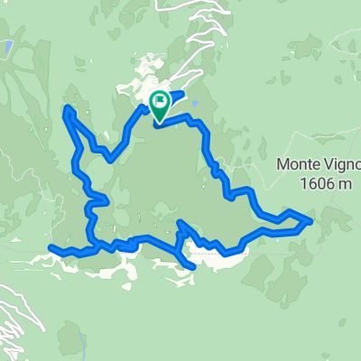
Tour of Monte Baldo starting from Sabbionara (agritourism Dai Menegheti).
Using the bike paths up to Zuane di Sotto.
- -:--
- Duration
- 86.9 km
- Distance
- 1,777 m
- Ascent
- 1,777 m
- Descent
- ---
- Avg. speed
- ---
- Max. altitude

Route quality
Waytypes & surfaces along the route
Waytypes
Road
38.2 km
(44 %)
Cycleway
20 km
(23 %)
Surfaces
Paved
83.4 km
(96 %)
Asphalt
83.4 km
(96 %)
Undefined
3.5 km
(4 %)
Continue with Bikemap
Use, edit, or download this cycling route
You would like to ride Giro del Baldo or customize it for your own trip? Here is what you can do with this Bikemap route:
Free features
- Save this route as favorite or in collections
- Copy & plan your own version of this route
- Split it into stages to create a multi-day tour
- Sync your route with Garmin or Wahoo
Premium features
Free trial for 3 days, or one-time payment. More about Bikemap Premium.
- Navigate this route on iOS & Android
- Export a GPX / KML file of this route
- Create your custom printout (try it for free)
- Download this route for offline navigation
Discover more Premium features.
Get Bikemap PremiumFrom our community
Other popular routes starting in Sabbionara
 Avio-Lago di Garda
- Distance
- 86.5 km
- Ascent
- 507 m
- Descent
- 507 m
- Location
- Sabbionara, Trentino-Alto Adige, Italy
 Sabbionara Corno della Paura
- Distance
- 27.7 km
- Ascent
- 1,424 m
- Descent
- 1,409 m
- Location
- Sabbionara, Trentino-Alto Adige, Italy
 Sabbionara-AcqueNere-Altissimo-Corno
- Distance
- 74 km
- Ascent
- 3,390 m
- Descent
- 3,375 m
- Location
- Sabbionara, Trentino-Alto Adige, Italy
 Corno della Paura Trails
- Distance
- 32.6 km
- Ascent
- 2,305 m
- Descent
- 2,304 m
- Location
- Sabbionara, Trentino-Alto Adige, Italy
 Corno della paura
- Distance
- 13.8 km
- Ascent
- 1,286 m
- Descent
- 1,286 m
- Location
- Sabbionara, Trentino-Alto Adige, Italy
 Aquile in Lessinia 5/9/2015
- Distance
- 19.6 km
- Ascent
- 348 m
- Descent
- 326 m
- Location
- Sabbionara, Trentino-Alto Adige, Italy
 Avio Torbole
- Distance
- 28.4 km
- Ascent
- 182 m
- Descent
- 242 m
- Location
- Sabbionara, Trentino-Alto Adige, Italy
 Giro del Baldo
- Distance
- 86.9 km
- Ascent
- 1,777 m
- Descent
- 1,777 m
- Location
- Sabbionara, Trentino-Alto Adige, Italy
Open it in the app