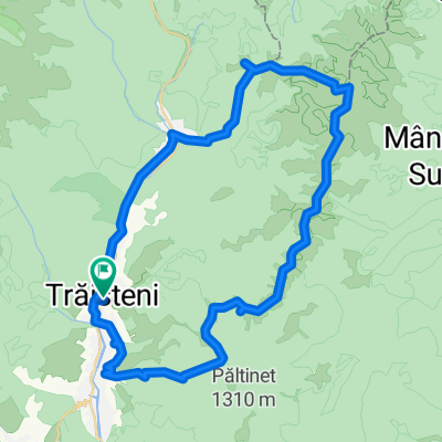
Muntele Grohotis ruta 1
- 24.3 km
- 488 m
- 1,172 m
- Trăisteni, Prahova, Romania
A cycling route starting in Trăisteni, Prahova, Romania.
Overview
Route through the Orjogoaia valley from Valea Doftanei to Azuga. Theoretically. Practically, the marking disappears after an hour and you stick to the forest road that is 100% clay and covered with dry leaves all the way to the alpine clearing. You pass the sheepfold and climb towards 'the Mountain with a cross on it - that's Cazacu' (directions from the mountain rescuer) - basically, you follow what remains visible of the tractor road over a meadow with dense grass, in tufts like perpetual molehills. In the fog, you can only go with the GPS. On the descent, I didn't climb up to Cazacu but under it and came out through the Ceausoaia valley - we called it Hell Valley (there was a trace of a road and the rest were just slopes with boulders up to the knees through which the stream flowed, just good not to stay dry down below). On the forest road leading to Azuga, there is a BROKEN bridge and you have to carry your bikes on your back. We took about 7h with luggage on the bike (tent, sleeping bag, sleeping mat, 30L backpack) and about 3L of water + many snacks. It's worth it when it's dry and you have light luggage - up to the clearing it might be worth trying the option with the Orjogoaia forest road, not the 'ridge' one.
created this 15 years ago
Route quality
Track
13.5 km
(62 %)
Path
4.8 km
(22 %)
Paved
3.3 km
(15 %)
Unpaved
10.2 km
(47 %)
Unpaved (undefined)
5.7 km
(26 %)
Asphalt
3.3 km
(15 %)
Continue with Bikemap
You would like to ride V. Doftanei - Azuga(+ rosu, Orjogoaia) or customize it for your own trip? Here is what you can do with this Bikemap route:
Free trial for 3 days, or one-time payment. More about Bikemap Premium.
Discover more Premium features.
Get Bikemap PremiumFrom our community
Open it in the app