

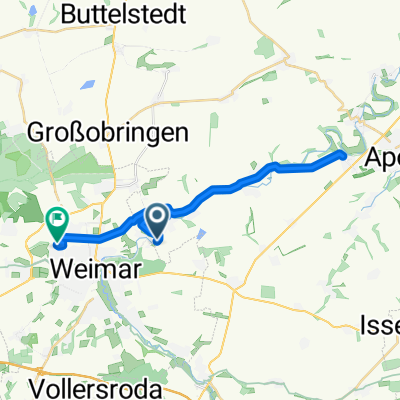
Mühlenrundweg Ilm-Weimar
A cycling route starting in Kromsdorf, Thuringia, Germany.
Overview
About this route
- -:--
- Duration
- 19.5 km
- Distance
- 159 m
- Ascent
- 157 m
- Descent
- ---
- Avg. speed
- ---
- Max. altitude

Route quality
Waytypes & surfaces along the route
Waytypes
Track
8.8 km
(45 %)
Quiet road
4.3 km
(22 %)
Surfaces
Paved
11.7 km
(60 %)
Unpaved
6.2 km
(32 %)
Asphalt
11.1 km
(57 %)
Loose gravel
4.3 km
(22 %)
Continue with Bikemap
Use, edit, or download this cycling route
You would like to ride Mühlenrundweg Ilm-Weimar or customize it for your own trip? Here is what you can do with this Bikemap route:
Free features
- Save this route as favorite or in collections
- Copy & plan your own version of this route
- Sync your route with Garmin or Wahoo
Premium features
Free trial for 3 days, or one-time payment. More about Bikemap Premium.
- Navigate this route on iOS & Android
- Export a GPX / KML file of this route
- Create your custom printout (try it for free)
- Download this route for offline navigation
Discover more Premium features.
Get Bikemap PremiumFrom our community
Other popular routes starting in Kromsdorf
 Mühlenrundweg Ilm-Weimar
- Distance
- 19.5 km
- Ascent
- 159 m
- Descent
- 157 m
- Location
- Kromsdorf, Thuringia, Germany
 Hotel Elephant Weimar-Tiefurt-Kromsdorf und zurück
- Distance
- 12.2 km
- Ascent
- 76 m
- Descent
- 76 m
- Location
- Kromsdorf, Thuringia, Germany
 Weimar/sulza
- Distance
- 30.1 km
- Ascent
- 116 m
- Descent
- 236 m
- Location
- Kromsdorf, Thuringia, Germany
 Dorfstraße 61, Kromsdorf do Moskauer Straße 132, Weimar
- Distance
- 8 km
- Ascent
- 85 m
- Descent
- 40 m
- Location
- Kromsdorf, Thuringia, Germany
 2014-08-02 Tiefurt Eberstedt
- Distance
- 50.7 km
- Ascent
- 214 m
- Descent
- 214 m
- Location
- Kromsdorf, Thuringia, Germany
 Dorfstraße nach Graben
- Distance
- 5.3 km
- Ascent
- 32 m
- Descent
- 55 m
- Location
- Kromsdorf, Thuringia, Germany
 Hauptstraße 2A, Weimar do Moskauer Straße 132, Weimar
- Distance
- 25.3 km
- Ascent
- 380 m
- Descent
- 340 m
- Location
- Kromsdorf, Thuringia, Germany
 Weimar - Artern
- Distance
- 94.8 km
- Ascent
- 303 m
- Descent
- 368 m
- Location
- Kromsdorf, Thuringia, Germany
Open it in the app